Author: hrbekm (Page 1 of 2)

The Book of John Mandeville: Medieval Map Analysis

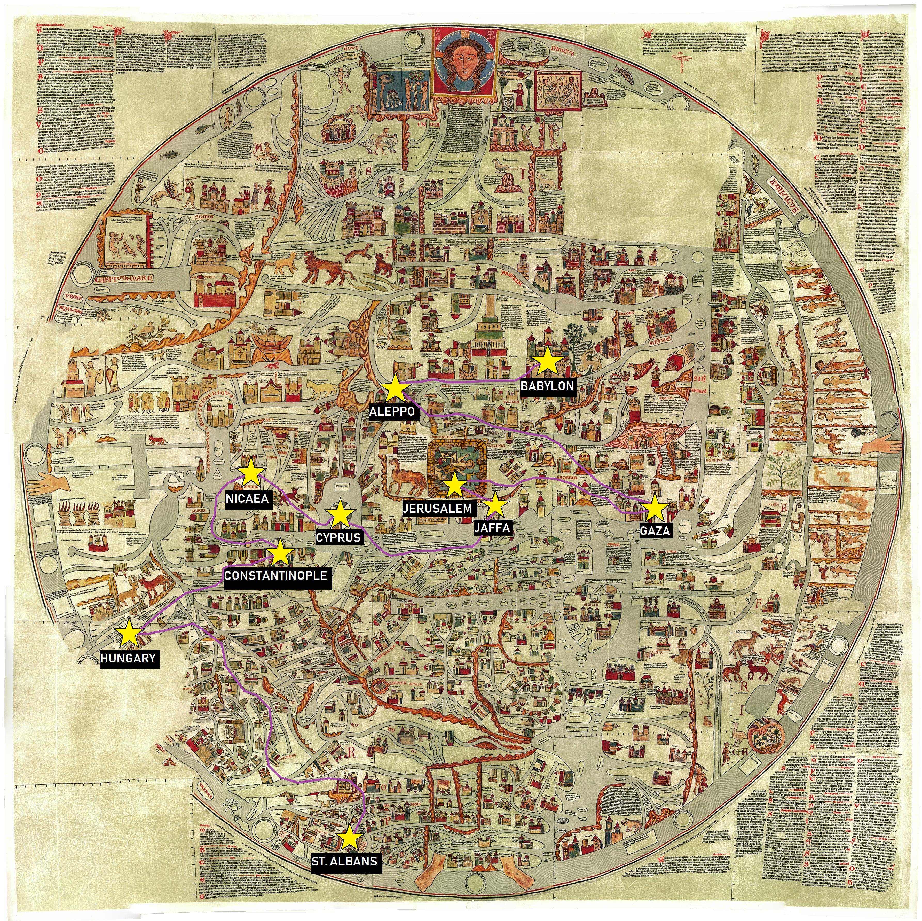
Transferring points and routes described in Sir John Mandeville’s Book of Marvels and Travels from a modern map to a medieval map posed unique challenges. Given the difficult-to-discern text on the medieval map and major differences in geographical thinking that went into its creation, locating the points themselves required much greater effort than simply typing names into a search bar on the GIS map viewer. Most location names were impossible to read on the image of the map itself, and medieval geography confused things further, with Hungary being placed northeast of the British Isles.

The two final images ultimately highlight the differences between past and present visualizations of the world. The past visualization in this case refers to that of medieval Western Europe. This worldview differs in obvious geographic ways from the modern map. To begin with, the Ebstorf mappamundi that I used to map my points is oriented with the East facing up and depicts only Europe, Asia, and Northern Africa. In addition, the city of Jerusalem is placed prominently in the center, being one of many symbols on the Ebstorf map that indicate the vital importance of the Christian religion in medieval European conceptions of the physical world. It is interesting that some locations appear closer together on the medieval map than they do on the modern one, while others appear to be similar distances on both. This is true even when one zooms in on the modern map to include only the scope of its medieval counterpart.

Centuries of scientific development went into the modern map I was working with. As a result, its geography is highly accurate and it encompasses much more territory of the physical world than what medieval Europeans knew existed, making the journey I mapped seem smaller in comparison. However, the details on the Ebstorf map communicate much more about how the journey Mandeville describes would have been conceptualized in medieval times. Its illustrations, text inscriptions, and wealth of religious symbols say that this is a journey pertaining to the aims of pilgrimage, and that it covers a significant portion of the known world. The modern map communicates more about the realistic aspects of the routes this journey requires, while the medieval map provides an extensive cultural context to the journey.

The Book of John Mandeville: Jerusalem

Much of The Book of Marvels and Travels is dedicated to discussing routes to Jerusalem, due to the city’s all-important status as the Holy Land and the place from which Christianity originated. As is typical of Medieval European thinking, Mandeville highlights through his narrative Jerusalem’s position as the center of the world, from which all else proceeds, both geographically and theologically. Because there is such a multitude of routes to Jerusalem presented within the narrative, and because Mandeville does not focus much on the practical or experiential aspects of travel itself, it would be a challenge to describe the physical journey to Jerusalem based solely on this text. However, if one was travelling from Western Europe as Mandeville claims to, then according to this text they would first arrive at the port of Jaffa after travelling through the Mediterranean. From there Jerusalem would be a day and a half’s travel over 27 miles of land.

Of the climate, Mandeville writes that it is dry with limited sources of water. Mountains and bodies of water are briefly described, most notably including the Dead Sea and the River Jordan. The former is one of few typical “wonders” in Mandeville’s Jerusalem, defying nature with bitter, still water in which no living thing can die. The latter functions primarily as a description of a holy site, with recollections of Jesus’ baptism and an Old Testament story concerning the river.

In describing the city of Jerusalem, the author of Mandeville provides some information on the landscape as well as historical and political background, but reports primarily in his writing on the holy sites that Pilgrims would go there to see. These include specific churches and temples and various relics kept in the city, as well as the physical locations associated with Biblical stories and places of general significance to the life of Christ. The most prominent examples of such holy sites in the text are the Church of the Holy Sepulchre and the Temple of Our Lord. Mandeville does not go into depth in this section on the political conditions in Jerusalem, but does emphatically note that “the sinful ones” (40) — here meaning Muslims — have possessed the city for over half a century, but will not continue to do so for long if God does not will it. This provides a deeper look into the medieval European conception of the Holy Land as a lost possession in the hands of those not faithful to Christ.

It is significant that in Jerusalem the author of Marvels and Travels focuses on specific holy sites pertaining to pilgrimage, because this was a place where one could, in theory, go and literally walk in the steps of Jesus Christ. Mandeville describes the process of the Crucifixion, and points to places throughout the city where Christ reportedly suffered or stopped to rest. If the text as a whole is considered with regard for its entertainment purposes, then an experiential account of destinations in Jerusalem that were typical for pilgrims to visit can be interpreted as a travel guide of sorts. It provides an imagined version of the Holy Land to European audiences who had an interest in the spiritual significance of these sites. This tactic also serves to justify the theme throughout the text of Jerusalem as the center of the world, by driving home the tangible origins of Christianity linked to the city.

The Book of John Mandeville: Babylon

Of Babylon, Mandeville present details on a wide variety of subjects, from physical and geographical aspects of the land, to political and cultural information, to his version of Babylon’s history. In a rare instance of inserting himself into the narrative, Mandeville claims he once lived there as a mercenary to the Sultan.

The Sultan of Babylon to whom he refers is said to be very powerful, ruling over five kingdoms. It is specified that this Babylon where the Sultan lives is not the same as Great Babylon, the ancient city referenced in the story of the Tower of Babel. To distinguish, Mandeville refers to the present incarnation as Babylon the Lesser. Great Babylon, by Mandeville’s account, used to be a great city on the banks of the Euphrates River, but after its decimation by a Persian king, it became an uninhabitable wasteland swimming with dragons and snakes. From Babylon the Lesser, this wasteland can only be reached by a 40-day journey through the desert.

Throughout the section in The Book of Marvels and Travels on the land of Babylon, several supposed routes to the city are described in detail. It is specified that the desert conditions surrounding Babylon make travel difficult, and one must ride a camel in place of a horse. Contrary to known modern geography, Mandeville positions Babylon “at the entrance of Egypt,” and also implies that one can go straight there from Aleppo. Though he does provide these hypothetical travel routes, Mandeville does not recount any particular journey undertaken.

Among the things Mandeville chooses to communicate about Babylon, his depiction of the Sultan stands out, and in particular the Sultan’s relationships with women. First, according to this account, the Sultan of Babylon always has three wives: one who is Christian and two who are Saracen (or Muslim). One of each must live in the cities of Jerusalem, Damascus, and Ashkelon. In addition to having wives spread out over different territories, the Sultan has access wherever he goes to as many women as he wishes to use as lovers. In whatever new cities he visits, he has the most attractive virgins brought to him. They are said to be detained, but detained “respectfully and with dignity.” It is unclear what exactly respect for women means in the context, beyond one statement that the virgin of his choosing will be washed and dressed nicely before meeting him in his bedroom. It is also emphasized in the passage that everyone who encounters the Sultan, and foreigners in particular, are expected to demonstrate the utmost respect for him, going so far as to physically kneel before him upon meeting him.

Considering these separate details as they relate to each other, Mandeville’s portrait of this Sultan contains the idea that a man who has earned the respect that comes along with the Sultan’s political domain has also implicitly earned a dominion and authority over the bodies of women and girls wherever he goes. This is upheld further in the text when it is said that the Sultan treats these women with respect when he is holding them against their will to keep at his disposal as sexual partners.

The Book of John Mandeville: The Land of Prester John

John Mandeville depicts the fictional land of Prester John in his Book of Marvels and Travels as somewhat utopic. He describes Prester John himself as an Emperor over all of the islands of India, overseeing the kings of seventy-two provinces, all whom have a number of other kings subject to them. The place where Prester John resides is called the isle of Pentoxoire, of which the greatest city is called Nisa. Mandeville emphasizes the wealth of this land, portraying it to be abundant with precious stones, including an entire river that is composed of gemstones instead of water, which flows out of paradise, through enormous mountains, and into a sea of sand which yields especially sweet-tasting fish. Prester John and most of his subjects are purportedly Christian. Though they do not possess “all the articles” of the faith extending from the organized Church authority of Western Europe, they believe in the Holy Trinity and practice the faith with great devotion. Mandeville lauds this fictional group of people as especially loyal, and caring not for material possessions.

Mandeville also describes the political nature of Prester John’s land. In addition to discussing how many kings are under his authority among the numerous islands of his so-called Empire, Mandeville builds up the mythology of this place by describing the composition of his court — kings, dukes, earls, bishops, and so on. He claiming that the Prester John always marries the Great Khan’s daughter and that the Great Khan always marries the Prester John’s daughter. This construction of a political relationship with an existing empire is interesting in its attempt to ground the land of Prester John in some reality. Some details of Prester John’s military forces and practices are also described. When he marches into battle against other rulers, he is accompanied by an army of “innumerable men” and gemstone-encrusted crosses are carried before him. This builds on the idealization of Prester John as a figure in the text: he is not only immensely faithful, but rich and noble and strong in battle as well.

Mandeville does not have much information to convey about the travel journey to the land of Prester John. He merely says that one can get there by travelling through Persia, and names a couple of cities one passes through along the way. Once one arrives at Pentoxoire, it takes a journey of four months to traverse it. He takes care to emphasize that the land of Prester John is incredibly remote and difficult to reach. He reports that, in addition to its remoteness, people from afar typically avoid going there because of the danger of sea travel. According to Mandeville, the presence of large adamantine rocks in the land of Prester John poses a particular threat to ships by pulling iron nails out of wood. These serve as convenient explanatory notes considering this land does not exist and Mandeville never travelled to any of the places in his Book of Marvels and Travels anyway.

Mandeville’s depiction of Prester John acts as a kind of assurance to Western European Christians: if one travels far enough past Jerusalem, one will reach Christianity again. This imaginary Christian empire on the other side of the world is presented as mystical, morally pure, and virtually unreachable, revealing the theological desires and uncertainties of the medieval European mind.

« Older posts

© 2024 Mapping the Global Middle Ages


Academic Technology services: GIS | Media Center | Language Exchange

Theme by Anders NorenUp ↑