Category: Ibn Fadlan (Page 1 of 7)
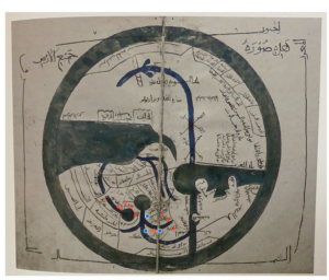
Ibn Hawqal’s World Map
- Bukhara
- Karawarazm (Kath)
- Jujaniya
- Zamjan
- Jit
- The Ghuzz
- The Banjanak
- The Bashghirds
- Saqaliba (Bulghar)
- The Rus
The differences between Ibn Hawqal’s KMMS world map and my modern Google map are almost immeasurable. More than millennium separating their creation dates, my modern Google map and Hawqal’s KMMS map could not be more different. The first and probably most obvious difference is the style of illustration. The Google map is a more accurate representation of the land. It has details regarding the terrain, tan indicating hot deserts, dark green indicating mountains, and white for areas covered by snow. Bodies of water drawn to size, relative to one another, with each bend in a river noted. The Hawqal map uses geometric shapes and minimal color. The bodies of water are rough estimates if anything. Seas, Gulfs, and Oceans grouped together because their distinction was not important. Their purpose was to indicate that there was water over in that direction, not to tell a reader what river they are crossing. Although rivers were dark blue, seas and oceans were a green-blue color. The land was not denoted with any color. This speaks to the purpose of the Hawqal map to not be used for exact navigation, but to be paired with a manuscript describing the distances and cities on the map. Another noticeable difference is the orientation of the maps. The Google map place North at the top and South at the bottom. The Ibn Hawqal map orients oppositely. The Google map also features the entire world if you were to scroll further in any direction. The Hawqal map, features just the reaches of the Muslim world, then drawn around is an “encompassing sea.” This was not necessarily to indicate the end of land in the world, just simply the end of knowledge of it. How the maps portray a nation or country’s borders is another significant difference between the two maps. While the Google map is exact and precise, the Hawqal map remains geometric. The Hawqal map draws out rectangular like boxes with the nations written in Arabic inside them, no specific cities are labeled. Medieval cultures understood the world differently than modern day cultures in that they understood people to be separated by cultural nations rather than borders. Borders were irrelevant to them if the people did not consider themselves of that nation.
The impact of mapping Ibn Fadlan’s journey on a modern map and Medieval map is striking because of the differing proportions of the two maps. I used the Charta Rogeriana, a compilation of the smaller maps from the Tabula Rogeriana, to approximate Fadlan’s journey on a map that would be as close as possible to what his group would have used to navigate. What is immediately noticeable is the orientation of the two maps. Modern maps are oriented with north at the top but Medieval Islamic maps orient with south at the top. Fadlan comments multiple times about the “cold of hell” that he experiences as he moves farther north. This idea is compounded by the extreme distance Fadlan appears to have travelled. Baghdad, his starting point, is very close to the center of the world on this medieval map, since it is close to Mecca. In comparison, Fadlan’s final destination of Bulghar appears to be close to the edge of the world. This creates a powerful visual of how differently Baghdad and Bulghar are thought of. Map makers of the time were well aware that the Earth is a sphere and the world was simply flattened in order to be viewed better on a piece of paper, just as we used different map projections to do today. However, the symbolic nature of medieval maps cannot be ignored. The power of the Abbasid caliphate, based in Baghdad, is emphasized due to its position close to the center of the world. In this way, the distance between Baghdad and Bulghar is real spatially, but possibly also spiritually in the beliefs of people living near Baghdad, where the map would have been created. In the modern map the proportions of the continents are more accurately depicted with Eastern Asia, Russia, and Siberia taking up huge swaths of land to the East. In the Medieval map, the East, in general, could be described as squished in comparison. The Abbasid caliphate, which Ibn Fadlan served, influenced the creation of this Medieval map and this is very clear since it’s seat, Western Asia, dominates the map because of its primary position at the center of the world and size in comparison to other areas. The leg of the journey shown between Baghdad and Bukhara also emphasizes this point. In the modern map, constrained to about the same size and viewpoint of the Charta Rogeriana, visually takes up about 1/6th of the width of the map. On the Medieval map this leg takes up about 1/4th of the map. This demonstrates the importance of the land owned by the Abbasid caliphate and their allies; it is shown as expansive and central to travel throughout the world. In comparing the two maps, it is also clear that the Arabian Peninsula is also the most accurately mapped. This speaks to the fact that geographers of the time would know their own land the best, but also to the enduring legacy of the Abbasid caliphate. The lost map of Al-Khwārazmi, a geographer that worked for the Abbasid in the 9th century, informed the creation of the Tabula Rogeriana and therefore the Charta Rogeriana. The Tabula was created in Sicily in the 12th century and the Arabian Peninsula is still the most accurate portion of the map in comparison to modern standards.