Page 2 of 39

Comparison of Modern Map and Medieval Map of Felix Fabri’s TravelsTh

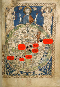
There are a plethora of differences between our modern world map and the Psaltic Mappa Mundi that Felix Fabri most likely used to trace his journey. For one, the modern world map that we use derives from satellite footage of the earth, and is therefore an accurate depiction of its landmass, water content, plates, etc. The Psaltic Map, which predates Felix Fabri’s journey to The Holy Land about 200 years, focuses less on accuracy of location and more on the importance of points relative to Jerusalem and other biblical landmarks. For example, despite their separation by large masses of water, Italy (Roma) and Jerusalem are depicted in proximity to each other, and the illustration does not depict a body of water that separates the two locations. In fact, Italy and Jerusalem are separated only by landmass on the Psaltic map, which implies that traveling from one place to the other can be accomplished on foot or on horseback, which is not the case!

In addition to the differences in accuracy and purpose between the Psaltic map and the modern world map, there is also a major difference in the maps’ orientations. Our modern world map is oriented from left (west) to right (east), and it captures lands that were undiscovered during the Middle Ages (i.e. North America). The Psaltic map, however, is circular, an attempt to depict the roundness of the earth. In addition, east is oriented at the top of the map where Jesus is depicted and Jerusalem is mapped in the center of the entire map. These were intentional choices made by the artist. East being located towards the top of the map near the deepcition of Jesus and Adam and Eve implies the region’s closeness to God, morality and purity. This ideology aligns with that of Felix Fabri, who revered places like Mt. Sinai, Mount Carmel and the Joppa Port. The farther away from the top of the map a region is, the less morally upstanding it is.

Marco Polo Map Comparison

Unsurprisingly, it was extremely difficult to map out the locations that Marco Polo had traveled to on the medieval map. On the modern map, it is much easier to visualize the distance that Polo had traveled, but due to the lack of labeling, or at least its visibility that the online version of the map had, it was hard to determine the route of his journey, therefore I was only able to determine the general region of the Middle East.

The Ebstorf Mappa Mundi goes into great depth of the mythological figures that were thought to be present in the world at the time, which contrasts the modern maps that are featured today. In seems to be that medieval maps, like that of the Ebstorf Mappa Mundi, were less fixated on accuracy, but more so a communication of culture, due to the lack of knowledge that the time had of the world. This goes along with the inclusion and focus on Christianity within the Ebstorf Mappa Mundi. Depicted in the medieval map is an image of Jesus embracing the world, with his head, hands, and feet, along with the inclusion of the Garden of Eden. The Ebstorf Mappa Mundi illustrates the key theme of religion that seem to reign during this time period, as the contents of the map are skewed in a Christian direction, as seen in having Jerusalem in the center of the map. There is no indication of any religious or political influence for the modern map, it simply consists of the geographic types of lands and the locations of countries, seas, etc.

I am very uncertain in the placement of the region in which I believe the Middle East is located, because even though the Ebstorf Mappa Mundi includes landmarks that were mentioned in Polo’s account, it was extremely difficult to read the tiny lettering of cities on the map, which is what I had to look for. I could only make out Sicily and India, and the general areas of Europe and Asia and Africa based on how T-O maps function. Since the Ebstorf Mappa Mundi is a T-O map, the direction and perspective is completely different to that of the modern day, as East is point towards the top, which helped in determining this. Due to the inaccuracies of the mappa mundi, it is hard to fully grasp the extreme distances that Polo traveled on this journey, which places less importance on the strife that he and other travelers had to deal with.

Finally, as previously mentioned, the Ebstorf Mappa Mundi, does a great job in illustrating culture, especially that of European origins, since it displays myths, landmarks, and religious inclusions that could assist individuals, like Marco Polo, in grasping the significance of certain locations and historical understandings to a specific region and community of people. The Ebstorf Mappa Mundi also assisted in sharing certain narratives about place and people within the world, since it had the ability to make judgements, such as dog-headed people living in a certain area, which caused these narratives to proliferate and thrive within the communities in Europe, but also reach other areas in the world.

« Older posts Newer posts »

© 2024 Mapping the Global Middle Ages


Academic Technology services: GIS | Media Center | Language Exchange

Theme by Anders NorenUp ↑