Great East Japan Earthquake (3.11)
The tolls taken:
In Japanese, Tōhoku means “northeast,” indicating a region of the country’s largest island, Honshū. On March 11, 2011, a magnitude 9.0 earthquake occurred off the Tōhoku coast of Honshū island. (The date of the event gives it the nickname of 3.11.) The earthquake is the 4th largest in history, and was a matter of global concern.
The earthquake triggered a tsunami with heights recorded over 20 meters in bay areas closer to the epicenter of the earthquake. Almost 16,000 people were killed from the disasters (Fig.6), 130,927 people were displaced from their homes, and thousands of travel-ways were completely destroyed (“USGS Earthquake Summary”).
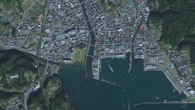
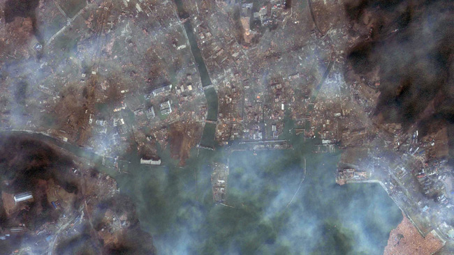
Minamisanriku was a city devastated by the tsunami (Fig. 9). Over 1,000 people were either killed or missing as a result of the disasters.
 Before 3.11
 After 3.11
Figure 9. Before and after pictures of the town of Minamisanriku
Click here to see more images of tsunami and earthquake damage
A variety of secondary hazards occurred as a result of the earthquake besides the tsunami, causing the casualties to rise (Fig. 7)
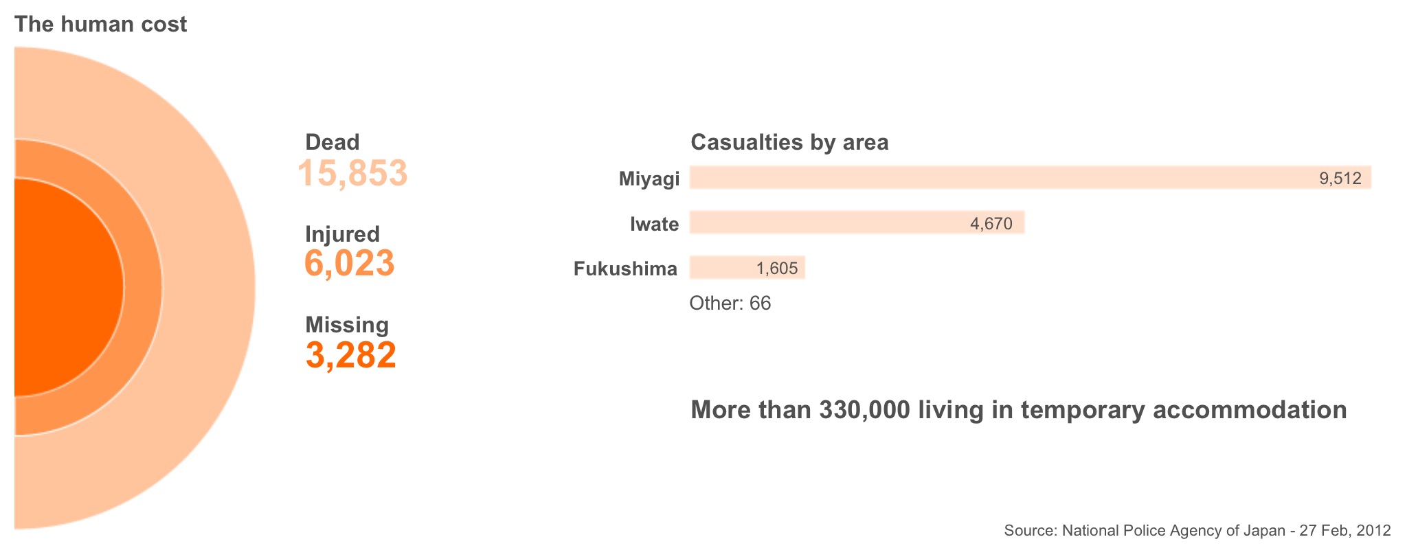
Figure 6. The number of people missing, dead, and injured by the areas severely hit by the tsunami. <http://www.bbc.com/news/world-asia-17219008>
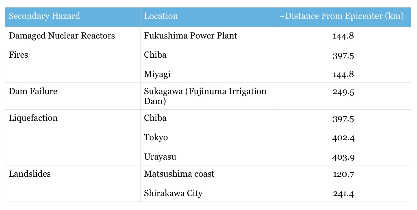
Figure 7. Secondary Hazards and their distances from the Epicenter (Sources: Chart made by Hayat Rasul; Hazards and Locations: http://earthquake.usgs.gov/earthquakes/eqinthenews/2011/usc0001xgp/#summary)
Tectonic Setting of the event: Quick Facts
- Epicenter: 38° 19′ 19.2″ N, 142° 22′ 8.4″ E, North Pacific Ocean
- Date: March 11, 2011 (3.11)
- Tectonic Boundary: Subduction zone; North American Plate and Pacific Plate
- (click here to see an animation of and learn about subduction zones)
- Fault Type: Thrust fault
- (click here to see an animation of thrust fault motion)
- Upward movement of ~30-40 m
- Largest earthquake since Dec. 1994
- Magnitude 7.8
- 3 fatalities
- The interchanging of deep and shallow ground patterns in bays like Minamisanriku’s Shizugawa Bay made similar bays and this one more prone to tsunami damage
- Water velocity increases in deep water
- Water height increases in shallow water
- A combination of the two leads to an intense tsunami impact ashore
- Fig.8
- Click here to watch animations on the tsunami’s wave-height dynamics specifically for 3.11
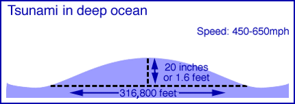
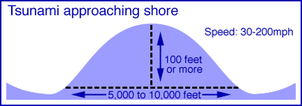
Figure 8. The changes in tsunami dynamics as the wave reaches the shore
Reference: “Magnitude 9.0, USGS”
Similarities and differences between Superstorm Sandy and 3.11 (CLICK HERE)