The explored (Un)just Sustainability in this project is the disproportionate distribution of Brownfields in the town of Carlisle, PA. Brownfields according to the EPA are areas that contain highly toxic and hazardous substances, pollutants, and/or contaminants which render redevelopment, or reuse of the property complicated. Such properties are highly dangerous to human health in the form of toxic chemicals. As cancer, reproductive, and developmental issues are recognized health effects of certain toxicants in brownfields (Litt et al., 2002). Physical health hazards are also widely present and pose a threat to public health as often time brownfields have unsafe structures, sharp objects, and uncovered holes (Wisconsin Gov). Although brownfields are not considered as dangerous to human health as much as superfund sites and are considered more of economic and social burdens on its communities, they are still highly hazardous spaces that directly affect the populations having to live near them. Through an analysis of the placement of this environmental bad in relation to environmental justice parameters such as race, income, and education in Carlisle, we argue that an unjust sustainability is taking place in Carlisle through the pattern of brownfield distribution locally. As we compared demographic layers on EJ screen map, our findings suggest that areas in the north of Carlisle, precisely north of High Street, which are areas that have higher percentages of minority populations, poverty levels, and lower education levels, have a cluster of brownfield sites, compared to the richer areas, that have higher education levels, and mostly white populations in south Carlisle. We argue that such a disproportionate and uneven distribution is a form of environmental injustice taking place in Carlisle, as more vulnerable populations who lack the voice and choice in decisions regarding toxic activity in their communities are being unevenly exposed to the health risks associated with brownfields.
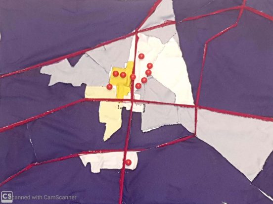
Project: Textile piece of a map of Carlisle representing different key demographics in town in relation to brownfield location. Demographics are race, income, and education with legend going from dark purple to dark yellow. The legend’s gradient starts with dark purple, light purple, white, light yellow, and dark yellow. Going from richer, whiter quadrants with high levels of income to quadrants with higher levels of poverty, minority populations, and low levels of education. Red pins were used to show the distribution of the 10 brownfields in Carlisle.

-H.A
Ben
May 1, 2020 — 4:19 pm
Excellent! Map is great visual for illustrating brownfield sites and economic inequities:)
Hiba
May 1, 2020 — 6:16 pm
Thanks Ben! 🙂
RM
May 1, 2020 — 5:50 pm
To me it was shocking to read that brownfield sites are seen as an economic and social burden and not really considered too much of a health concerns, considering that the government knows what issues they cause. Your visual is very creative and clearly shows the unjust practices regarding your environmental bad. I’m curious is the towns adjacent to Carlisle follow the same trends.
Jorden
May 1, 2020 — 5:51 pm
Very interesting. I wonder if it would be useful to map “greenfield” locations as well.
Hiba
May 1, 2020 — 6:19 pm
Thank you 🙂 and yes, investigating Greenfield distribution in Carlisle would be interesting as it might shed some light on which sites are prioritized for cleanup or redevelopment.
MR
May 1, 2020 — 5:56 pm
I appreciate you doing Carlisle as your location as I had no idea how many brownfields were prevalent in this area and this visual really shed light on the amount of pollution in the area.
Hiba
May 1, 2020 — 6:20 pm
Thank you! Yes, it was informing for me as well as I was building this project to visually see the distribution of brownfields in our town.
gontareg
May 1, 2020 — 5:58 pm
The strength of the correlation between these demographics and brownfield site locations is shocking! I wonder if this has implications for property value and health problems within the area.
A.R.
May 1, 2020 — 6:04 pm
Great visual and research! I really enjoy learning more about Carlisle.
When looking at the issue of brownfield sites, were there any other environmental bads clustered in the same areas? I know that in Carlisle food security is a huge issue but I am unsure of other environmental injustices. Additionally, when we did a walk we saw public housing being built – I am curious to know the proximity of new housing being built to these brownfield sites.
bromleyd
May 1, 2020 — 6:05 pm
This is so interesting to look at especially considering the day we talked about how the minority population in Carlisle is mainly concentrated around current and abandoned industrial sites. To see the consequence of racial zoning in Carlisle, and how concentrated brownfield sites are is really eye opening.
Hiba
May 1, 2020 — 6:30 pm
Exactly, I was inspired from our past discussions and field trips around Carlisle to investigate this a little further. Thank you!
messimeg
May 1, 2020 — 6:05 pm
I had no idea there were so many brownfield sites in Carlisle, and the visual for this is a great way to show the correlation between them and the demographics of residents. Great job!!
Hiba
May 1, 2020 — 6:28 pm
Thanks!
Kristin
May 1, 2020 — 6:12 pm
What do the different colors of material on the map represent? Is that connected to poverty levels?
Hiba
May 1, 2020 — 6:28 pm
Yes, they were based on poverty levels. Other demographics such as education levels and minority populations also followed a similar trend though. Quadrants that have the highest levels of poverty are the same that have the lowest levels of education and high presence of minority populations.
Prof. Michael Heiman (emeritus)
May 1, 2020 — 6:16 pm
Brownfields are contaminated areas with the potential to be brought back into productive use and add to the local tax base once again. One has to look at the history of the specific sites to understand the EJ issues involved. In the Carlisle case, the designated brownfields were industrial sites that attracted lower-income working-class residents nearby who worked in those factories (e.g. the former trailer park across the street from the plant–Carlisle Tire and Wheel on Hamilton)? The redevelopment plan was actually put together by a team led by a former Environmental Studies alum. In any case the question then becomes one of which came first–the offending factory or the residents across the street? Prof. Vickie Been (NYU) argued that if the factory came first it couldn’t be accused of environmental injustice nor was there even an injustice. I was of a different opinion (and wrote about it)–That we have to get beyond the Chicken and Egg debate–rather it matters little if the factory was there first. If the subsequent workers/residents couldn’t afford to move to a cleaner residence, what we have then is institutional injustice, even racism, as we must consider the sociology-economic conditions that forced those residents to live in a trailer park across the street (to take the Carlisle example).
Kathryn
May 1, 2020 — 6:30 pm
Have you looked into the plans for reusing these brownfield sites? Some old sites have been remediated into low income and veteran housing and there are also some really interesting plans in the works for the brownfield sites near the fairgrounds.