Month: November 2025 (Page 2 of 6)

Medieval Map Assignment


Link to Medieval Map!

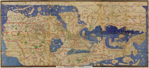
Placing the itinerary of The Travels of Sir John Mandeville within the visual context of the Hereford Mappamundi helps to alleviate the confusing nature of both sources, independent of one another. While John Mandeville speaks to the importance of various places, the Mappamundi emphasizes the visual authority of a given person, group of people, or place. Nonetheless, both serve the same function of showing a Medieval Christian audience the far-reaching influence of Christianity in the known world.

Mandeville places his origin in St Albans, a city north of London and west of Hereford, where the Mappamundi has been on display for centuries. The origin of both the map and the text being in such close proximity to one another underscores their connection. With that being said, neither the Mappamundi nor Mandeville emphasizes England within the context of the known world. Mandeville seldom mentions his home country or its government, while the Mappamundi presents England as nondescript and sans marvels–a contrasting portrayal compared to other locations.

Constantinople is the first place Mandeville truly travels, receiving attention on account of its relevance to the author, who claims to be a Christian pilgrim. Mandeville predicates Constantinople’s importance on its Christian relics, in addition to the Church of Santa Sophia and its accompanying sculpture of the Emperor Justinian I. The Mappamundi includes Constantinople as well, labeling its location alongside a structure reminiscent of the Church of Santa Sophia. The continuity of the Church in both Mandeville and the Mappamundi highlights its status as a holy site within the Christian mind. 

The Hereford Mappamundi includes a myriad of Greek islands and cities, just as Mandeville enumerates in his travel account–Ephesus and Patera among them. Mandeville’s convention when describing Greek territories is to accentuate the difference between Greek Christians and his own concept of Christianity. Furthermore, he simultaneously recounts regional myths and Christian history, framing the intersection of pagan and Christian ideologies in the Medieval Mediterranean. There are several Classical references throughout the Mappamundi, complicating its function as a Christian storytelling device. These allusions, in tandem with Mandville’s own Classical education, reveal the literacy of both sources’ intended audience.

For Mandeville, Cyprus is an extension of his commentary on Greece as he highlights its strong Christian government, in addition to several holy sites on the island. He marks Cyprus as a crucial stop for travelers on their way to Jerusalem, and yet, the Mappamundi does not give Cyprus the same visual importance. Instead, it is largely unidentifiable, as the map seeks to spotlight marvels.

Another significant piece of continuity between The Travels of Sir John Mandeville and the Hereford Mappamundi is the placement of Jerusalem at the physical center of each source. Mandeville traces multiple routes to the Holy Land, while also addressing all of the Biblical and historical connections to the region. Similarly, the Mappamundi carves out space to showcase the crucifixion as well as a compass at Jerusalem. This strategic visual reminds the viewer what is most important: Christ.

The geography of Sicily in relation to Babylon is misconstrued by Mandeville and the Mappamundi. Both the text and the map mislabel Sicily’s location. Mandeville asserts that in order to get to Babylon, one must pass through Sicily, which is geographically counterproductive. On the other hand, the Mappamundi places Sicily west of Rome and south of Crete, neither of which are accurate. Its inclusion speaks to its importance within the Mediterranean world, but its misinterpretation–across both sources–demonstrates that neither Mandeville nor the craftsmen of the Mappamundi have acute geographical knowledge.

Egypt is a significant arena for marvels in the Mappamundi, which is aptly echoed in Mandeville’s account. The most fascinating parallel is the presence of a fauna on the map, and Mandeville’s anecdote about a half-goat, half-man being he allegedly encounters in Egypt. This is a blatant instance of Mandeville compiling content from other sources in his travel writings. That being said, Egypt is where Mandeville first describes people with dark skin. The Mappamundi does not focus on identifying ethnic or religious groups by skin color, but instead by physical characteristics, often represented through extremes and deformities.

India is an additional location where Mandeville and the Mappamundi overlap. Numerous times throughout his account, Mandeville describes the various people he meets with physical differences–one which being people with one large foot that encompasses their entire body. The Hereford Mappamundi has an illustration that perfectly coincides with Mandeville’s writing, in the same location: India. Similar to Egypt, Mandeville likely borrowed his description from the prior drawing on the Mappamundi.

Mandeville’s section on the Land of Gog and Magog is an extension of the anti-Semitic imagery depicted in the Hereford Mappamundi. In his writing, Mandeville asserts that the Land of Gog and Magog is where the Ten Tribes reside in the Caspian Mountains, labelling them as evil and inhumane. Additionally, he notes the numerous gryphons native to the region, which are also present within the map. The Mappamundi itself is full of various stereotypes of Jewish people, including Moses with horns and Jews worshipping a calf. These portrayals reflect the deep disdain certain Christian sects felt towards Judaism. The placement of Gog and Magog in the far East within both sources further ‘others’ the Jews they are intending to depict. Although Mandeville’s text and the Mappamundi are intended for a Christian audience, they are marred by their staunch anti-Semitism. 

The legend of Prester John is pervasive throughout various Medieval travel accounts and narratives. Mandeville himself falls into the trope, repeatedly alluding to Prester John, before finally describing him and his palace in Babylon. Prester John’s wealth and abundance is heavily emphasized by Mandeville. There are a few instances in which Mandeville references the Tower of Babel, but it is not a major talking point for him. On the other hand, the Mappamundi identifies Babylon by the Tower, emphasizing its function as a Biblical setting  rather than settling for the city’s connection to a fictional person.

Both The Travels of Sir John Mandeville and the Hereford Mappamundi have several shared narratives, images, and stereotypes. Each source reinforces the function of the other, helping the audience to understand what it means to be a Christian in 14th century Europe. The spatial awareness of those in this era was broadly limited, and yet, to know about a different place, in any capacity, distinguished oneself. That being said, the target audience members for both the text and the Mappamundi were Christian, English people equipped to read, write, and work. The prospect of journeying to such faraway places like Mandeville was impossible to most. Thus came the ability to pursue a mental pilgrimage alongside this book and this map.

Medieval Travel Map Assignment – Margery Kempe


Tristan Deliana Link to Story Map because it gets cut off on the blog post: https://uploads.knightlab.com/storymapjs/16945eb4b6d4bd1c035a3a3eb37beb86/margery-kempe/draft.html

     A modern day map and the Hereford Mappa Mundi have drastically different styles of mapping the world but both contain vital information pertaining to travel. Modern day maps do not contain a subjective world view, but rather keep a more objective and neutral lense. They display the world as it is, with minor unintended errors such as enlarging countries. For example in the Mercator projection, due to attempting to place a 3D spherical world on a flat plane. Modern day maps display countries that are partially or entirely recognized, indicating borders, cities, and terrain of the area. They are useful for accurate navigation and for understanding the geographical location of an area and its terrain. They do not usually contain mythological or religious elements to them and remove the sense of the unknown due to technological advances in mapping and seeing the world. Using a modern map, the physical extent of Margery Kempe’s travels is truly revealed, displaying visually the large distance she had to cover from England, across the European continent, and to Jerusalem. It gives a realistic idea of what route she may have had to take, the distance she would have had to travel, the time it would have taken, and the terrain she would have had to overcome. It gives a pragmatic view of her journey without any bias, and can allow the viewer to either mentally or physically replicate her journey. It is devoid of subjective perspectives or prejudices that can affect the perception of how locations are, or what they should be like. For example, on the Hereford Mappa Mundi, the labyrinth of Minos is present whilst in reality, if someone were to have followed the Hereford Mappa Mundi they would find no such labyrinth, at least in the area indicated. 

  The Hereford Mappa Mundi on the other hand itself focuses much less on precise geographical depictions like a modern map and more on presenting the religious worldview. In comparison to a modern map, Margery Kempe’s journey on the Hereford map appears much shorter. On the Hereford map, cities are placed much closer in proximity to each other, countries are distorted and shrunken to conform to the T-O style that places Jerusalem at the center of the world. Margery’s journey on the Hereford Mappa Mundi looks as though she had traveled much less than she actually did. It does not display detail of terrain other than very broad imagery used to display rivers and the Alps, making her journey look flatter and relatively simple. This is because the map is not intended for accurate navigation but for the average viewer to have a certain view of the world around them.The map was created with religious iconography and placed into a Catholic cathedral displayed to a Catholic parish. It was intended to display an English Catholic perspective of how the world is assumed to be.     

    The map depicts Christ at the top with angels holding inscriptions whilst other angels turn themselves to look at the world and to the saints around them. These drawings and inscriptions visibly present two core Catholic beliefs. Christ is God and the king of both Heaven and of Earth itself. The second being that the saints are alive in heaven and can engage in intercessionary prayer. The map also displays biblical events and locations and places Jerusalem as the center of the world since this is where Christ was crucified and resurrected giving salvation to all of humanity. This gives more emphasis to the religious aspect of Margery’s journey. She does not travel for politics nore economic motivations. She does not travel with the intent of finding new lands and exploring. Her sole intentions are religious in nature, motivated by the Spirit of God to visit holy sites for the benefit of her soul. The Hereford map displays the cross with Christ on it directly above Jerusalem, which is in the middle of the map, telling the viewer that at the center of it all is Christ and the salvation He brings to humanity. Margery herself is departing from England with the intention of arriving to Jerusalem for pilgrimage, she travels to not only the center of the world, but also the place that holds sites of the faith that is the center to her life. In this aspect, the Hereford Mappa Mundi is more faithful to Margery’s journey and account in comparison to a modern map. In her narrative, Margery never describes the exact route she takes, the terrain that she must travel through, and rarely describes someone’s ethnicity or culture. The focus of her narrative is based on religious nature, and if it talks about something else it is always tied back to her faith, religion, or Christ. Just as her narrative, the Hereford Mappa Mundi places emphasis on Christ, Catholic doctrine, religious sites, and mythological mysteries rather than practical matters like distance. 

     A modern map and the Hereford Mappa Mundi may appear stylistically very different but both serve an important role in understanding the world and travel, specifically that of Margery Kempe. A modern map will give genuine appreciation to the large scale that Margery had to travel and the terrain she had to overcome. It will give an objective view of the world she had to travel through, with the exception of modern day borders. The Hereford Mappa Mundi gives emphasis to the purpose of her travels, and allows the viewer to gain access to how Margery herself would have seen the world. It allows the viewer to see the importance of faith and how it affects a person’s motives, specifically pertaining to travel and pilgrimage and can give a better insight to Margery’s thought processes that she details in her book. 

Link to Story Maps: https://uploads.knightlab.com/storymapjs/16945eb4b6d4bd1c035a3a3eb37beb86/margery-kempe/draft.html   

Pictures used for storymaps: 

Rome: https://commons.wikimedia.org/wiki/File:St_peters_basilica_interior_drawing.jpg

Assisi:https://www.posterazzi.com/assisi-italy-in-the-late-19th-century-from-el-mundo-ilustrado-published-barcelona-circa-1880-posterprint-item-vardpi1958095/?srsltid=AfmBOoqewbND0DcoXcG5Yb_XIIWN7LZLZNK-_HEjUibWqMEzv9L-zkCp

Venice: https://www.britannica.com/biography/Gentile-Bellini

Jerusalem: https://www.saintjohnchurch.org/palm-sunday/

Bologna: https://en.wikipedia.org/wiki/Towers_of_Bologna

Konstanz:https://www.meisterdrucke.ie/fine-art-prints/Unknown-artist/915499/Exterior-view-of-the-Notre-Dame-Cathedral-in-Constance,-Germany.-Engraving-in-%27The-Universe-illustr%C3%A9%27.html

Zierikzee:https://www.alamy.com/ruin-of-the-sint-lievensmonsterkerk-in-zierikzee-after-the-fire-of-1832-the-st-lievens-monsterkerk-in-zierikzee-daily-after-the-brandview-of-the-building-of-the-sint-lievensmonsterkerk-in-zierikzee-after-the-fire-of-october-6-1832-on-the-left-the-tower-that-has-remained-intact-right-the-destroyed-church-building-image414430917.html

Yarmouth:https://commons.wikimedia.org/wiki/File:St._Nicholas_Great_Yarmouth_1864_Ecclesiologist22camb_0047.jpg

Norwich:https://www.periodpaper.com/products/1919-print-norwich-cathedral-norfolk-england-architecture-landscape-dayes-art-129953-xac9-036 

Norfolk:https://www.wellandantiquemaps.co.uk/product/st-margarets-church-west-front-lynn-norfolk-by-mackenzie-le-keux-c-1809-2/ 

Virgin Mary Fighting Devil:https://www.bl.uk/stories/blogs/posts/the-medieval-origins-of-mothering-sunday 

Saint George Drawing:https://monarchies.fandom.com/wiki/Saint_George%27s_Cross?file=St_George_BNF_Fr_241_101v.jpg

Ship drawing: https://modelshipworld.com/topic/25896-medieval-longship-by-bolin-finished-130-based-on-reconstruction-helga-holm/ 

Holy Roman Empire drawing: https://themiddleagesperiod4.weebly.com/the-holy-roman-empire.html

Christ Middle ages depiction: https://ica.themorgan.org/manuscript/page/30/77488

The Annunciation drawing: https://michaelfaletra.weebly.com/virgin-mary.html 

Crucifixion: https://ica.themorgan.org/manuscript/page/18/77488


Medieval Travel Map: The Travels of Ibn Battutah

The Tabula Rogeriana was not a one to one accurate map, but considering it is a Muslim map it was ideal for plotting Ibn Battutah’s journey. Mecca was at roughly the center of this map as the most important city to the religion of Islam and the original goal Ibn Battutah had when leaving his home of Morocco for the first time. Besides the geography of the time being somewhat inaccurate, this map gets the general shape of landmasses correct. This made mapping the locations easier than most medieval maps and also makes it easier to read coherently, as long as the reader knows which way it is oriented. Once again because of the Islamic craftsmanship, this map is oriented with south at the top and north on the bottom. East and west are also flipped accordingly, which can cause some difficulty with locating things. The scope is also perfect for tracking Ibn Battutah, as his entire journey never leaves the bounds of this map. Morocco is far on the right hand side and the farthest east he goes is Peking in China, all of which is present there. For its time, the Tabula Rogeriana was considered a world map since the Americas had not been discovered yet. Some known land was omitted from this map of the world, namely the southern two-thirds of Africa. The map was centered around not just Mecca it seems but the entire Islamic world, as at the time the majority of this land was under Muslim control. Seeing as the only parts of Africa that made it in were the northern countries that were primarily Muslim, the continent was likely cut out pertaining to relevance for those that might be reading the map, as well as the cartographer’s own desires.

Ibn Battutah probably did not use maps much at all during his time travelling, mainly due to ease of access. It was also fairly easy to hire guides or rely on slaves that could speak the language of the foreign country they were navigating. Muslims at this time also relied little on written documents and more on memory, with Ibn Battutah’s entire travels even being recorded by his later recounts of them. If he did have some form of map, it was likely lost or stolen as happened to many belongings he travelled with over the years. Aside from the likelihood of him carrying a map, Ibn Battutah would have agreed with the way the Tabula Rogeriana shows the world. Being a jurist of his faith, Ibn Battutah’s whole journey revolved completely around his religion and how it should be practiced. His constant policing of his religion throughout the lands he travels falls in line with the Muslim centric view of the world seen in the Tabula Rogeriana. Mecca’s centrality would also likely please him, as the pilgrimage was so important to Ibn Battutah that he did it more than once in his lifetime. With Islam being such a big part of his life and in some ways his purpose, having the world displayed as it is in the Tabula Rogeriana would be validating to say the least.

As a jurist, Ibn Battutah saw the world in relation to the laws of Islam and its practice. His pilgrimage was the original intention of his journey, but after reaching Mecca he traveled farther to spread his faith and act as an advisor to foreign rulers. In the modern day, it is generally frowned upon to travel somewhere and critique local customs or be judgmental of cultural and religious differences. While it may have been his job, Ibn Battutah judges cultural differences often, sometimes openly to whatever government official is in front of him. Not only would the more cautious and respectful mindset modern travelers have be lost on him, but Ibn Battutah would likely find it difficult wanting to travel anywhere as the Muslim world is significantly smaller than when he was alive. Given the larger reach of Islam, he also encountered many Muslims wherever he went and was met with primarily Muslim countries and cities. Traveling today, he would not be received with Muslim hospitality in every city and not be given such special treatment either, resulting in miserable conditions for travel in terms of what he thought of as standard.

So considering Ibn Battutah’s journey in relation to not only the Tabula Rogeriana but also modern day maps, it appears that the medieval map would be preferrable for him. Not only would it be better in line with his beliefs, but the differences in the modern world make it hard to imagine Ibn Battutah traveling in it or using modern maps.

Ibn Battutah – Medieval Map

Storymap

The most significant difference between al-Idrisi’s Tabula Rogeriana and our modern Google Earth map, is, of course, its orientation: the Tabula Rogeriana is oriented south-up, and we in modern times are most accustomed to thinking of north as upwards. This difference reflects a variation in religious and cultural beliefs. Muslims, such as Muhammad al-Idrisi, the map’s creator, and Ibn Battutah, a well-traveled medieval jurist, would think of south as being downwards and closer to hell, because in Islamic cosmology hell was cold. On the other hand, our modern satellite maps, made in a culture dominated by those of European descent, continue to place the European continent at the top of the world. And because this culture is also largely dominated by Christianity, we might tend to think of the hotter southern lands as being more hellwards. Ibn Battutah might have thought of his journey as being relatively safe (at least, as safe as travel could be in that era), because he remained mostly in warmer, more “heavenly” zones, and didn’t journey terribly far into the hellishly cold northern climates. The Tabula Rogeriana also places Mecca as the center of the world, which is something Ibn Battutah likely would have internalized as well. A modern satellite map, however, has no center, and one can scroll across the whole map in one seamless loop.


The Tabula Rogeriana contains only the world that was known at the time, and focuses mainly on Europe, West Asia, and North Africa. It is most detailed around the Mediterranean, and becomes less detailed the further east it goes. Eastern cities such as Delhi, which Ibn Battutah visited during his travels, are nowhere to be found on the map. So embarking on such a journey could feel dangerous, as one is quite literally stepping into the unknown. Travel during modern times, on the other hand, is far easier to navigate, since satellite maps are able to provide an accurate image of an area, down to specific buildings and landmarks. Traveling is far less stressful and pathways are less unknown, because if one is lost, one can simply open the satellite map and use their location to pinpoint exactly where they are in relation to everything around them. Modern maps also allow us to view the entire world, because we are able to literally send a camera up into space and take pictures of everything, and so we have knowledge of entire continents and landmasses that were completely unbeknownst to the people of Ibn Battutah’s time. 


The Tabula Rogeriana is surprisingly accurate for a map made long before the era of satellite photography. To draw the shapes of the landmasses so faithfully, especially over such a large area, is an impressive feat indeed. That being said, the map is the most accurate along the coastlines of the Mediterranean. It would, after all, be far easier to draw a city located on the coast than to draw one further inland, where there may not be as significant a geographical feature to locate it by. While mapping Ibn Battutah’s journey on the Tabula Rogeriana, I had a far easier time locating the coastal cities he visited. With the inland ones, though, I sort of had to take my best guess and zoom in, and then scan around a lot until I found a phonetically similar name (as I cannot read Arabic, I used a version of the map that had been helpfully transliterated into the Latin alphabet). For travelers such as Ibn Battutah, moving away from the coastline may have felt more like entering uncertain territory, since it’s easier to get lost and disoriented without an idea of what landmarks you can reference along your way. The Tabula Rogeriana also does not make any real distinction between cities based on size or landmarks, although there are a few exceptions. Alexandria is drawn with its iconic lighthouse, and there’s a grouping of four cities further east surrounded by a circular, almost spiky looking wall. Beyond that, though, there’s very little to differentiate one city from the next. Natural features such as mountains or rivers abound, but if one were to become completely lost and stumble upon some mountain or river, it would be very difficult to identify exactly which one you were looking at by using the map. Or, worse, you could follow a river or navigate around a mountain believing it to be the landmark needed to stay on your route, only to discover they were two completely different mountains and you’ve gone the wrong way entirely. Your best hope in order to ensure you take the right path and get to your destination would be to rely on locals familiar with the area. Much different than travel in this day and age, when any idiot can pull up Waze to tell them which route to take.

Medieval Map Assignment – Felix Fabri and the Psalter World Map

My Medieval Map: https://uploads.knightlab.com/storymapjs/3d3e14d6ff5bf791e8df42414c25f59c/medieval-map-assignment-gillie-schmidt-quee/index.html

The Psalter Map illuminates a similar conceptualization as Felix Fabri’s pilgrimage to the Holy Land in the late Fifteenth Century. The Psalter Map was published sometime after 1262, over a century before Fabri’s journey in 1483 (Wacha 2020). However, when read alongside one another, they present a dominantly Christian religious conception of the world that places Jerusalem in the center. By comparing Felix Fabri’s route on the Psalter Map to a modern one, it becomes evident that society has de-centralized Jerusalem and no longer presents objectivity through religious understanding. Instead, modern maps are focused on scale, geographic features, nation-borders and distinctions, and population density. While the shape of Fabri’s journey stays the same, the presentation of his route and the concepts around each location have shifted away from religious bias and towards a more objective representation of geography and distance. 

The most apparent difference between a modern map and the Psalter World Map is its orientation. Like many maps of the time, the Psalter World Map is oriented so that East faces upwards, unlike the modern representation of North at the top. Another significant visual difference is the shape of the map. The Psalter World map is circular, and represents the world as it was known with only three continents: Europe, Asia, and Africa. Prominent cities and geographic features shape the map. Places like Rome, Macedonia, and Cyprus are illuminated, and the Mediterranean Sea, the Alps, and the Sahara Desert are clearly marked physical features. The Psalter map distorts the rest of the world around Jerusalem so it appears superior and uses geographic boundaries to reinforce their physical impact on travelers’ journeys. The Psalter Map is surrounded by religious iconography and references which present the world through a starkly Christian lens. While modern maps still represent man-made and geographic elements, the presentation is much less subjective. Technology such as Google Maps use satellite photography to present an objective view of the world. The implementation of photography shifts away from religious iconography as a means of representation and instead mirrors what one sees. Maps still employ symbols to show significant landmarks and borders, however these icons are no longer shaped by religious storytelling and instead work to mimic reality. 

We learn early on in Fabri’s narrative that travel is esteemed and is not accessible to everyone. However, Fabri embarks on his second wandering because he “was by no means satisfied” with his previous “short and hurried” journey (Fabri 3). While he is hesitant to ask to return to the Holy Land, he does it anyway and vows to himself that this time he will record the journey – hence The Book of Wanderings. Fabri perceives Germany as a superior and dominant nation, a perception that is not shared with the Psalter World Map’s presentation of the world. The Alps are a significant landmark for the map, however Germany itself is not labeled and does not give the same importance as Fabri’s account of his nation. His world view is created by both a religious and nationalistic understanding to reinforce the accuracy and reality of his narrative. Fabri’s representation of German superiority builds on Christian hegemony and narrates a shift towards nationalism after the creation of the Psalter Map. 

The Psalter World Map and Felix Fabri’s Wanderings visualize distance and location through a dominant, Western, Christian perspective. In the second half of his narrative, Fabri emphasizes his desire to visit Mount Sinai and the convent of Saint Catherine, another important location for religious pilgrimage. However, he resists this desire because of the extreme distance. He wants to “go as far as Mount Sinai” and appeals to church leaders, however it is understood that Mount Sinai is just too far (Fabri 50). The Psalter Map represents this distance, from Jerusalem to Egypt looks just as long if not longer than the Alps to Jerusalem. The map places Egypt in a far corner close to the unfamiliar and threatening drawings of “monstrous races” (Wacha 2020). This distance and Mount Sinai’s closeness to the monstrous races ostracizes the location and presents it as completely foreign – thus informing Fabri’s conception that it is of a different land. The inherent racism of Christian society’s understanding of the world is written into Felix Fabri’s narrative and his understanding of location. He blames “Saracens” for the corruption of Saint Catherine’s convent, and goes further to describe them as having “heads like dogs, with long ears hanging down” (Fabri 54). His representation is mirrored by the Psalter map’s illustrations and together it becomes evident that these hegemonic ideas were not only prominent in religion but also influenced political and social understanding. 

The narrative and the map work together to project Southern lands as both dangerous and unhuman, which continues to fuel the discourse and Fabri’s understanding that Mount Sinai is an unattainable destination regardless of his desire. Modern maps help disprove the racist projection of the Middle Ages, and make it apparent that this conceptualization is skewed. In actuality, Mount Sinai is only 330 miles from Jerusalem, while Ulm (Fabri’s starting point) is 2,425 miles from Jerusalem. Additionally, one could travel from Jerusalem to Mount Sinai on land whereas it took Fabri many weeks of sailing on the Mediterranean to arrive in Jerusalem. It would have taken Fabri a fraction of the time to continue to Mount Sinai, especially after going on pilgrimage not once, but twice. Modern tools illuminate that the journey to Mount Sinai would have been attainable for Fabri, information that was not available to him because of Christian framework. It is helpful to compare the two visualizations to understand the rigidity of the world view Fabri was traveling with. Modern tools present accurate distances which shows the falseness of Fabri’s understanding and the impact of the Christian world view in shaping ideas of space, distance, and familiarity. 


Works Cited 

Fabri, Felix. “The Book of the Wanderings of Felix Fabri (Circa 1480-1483 A.D.)” trans. Aubrey 

Stewart. 2 vols. London: Palestine Pilgrims’ Text Society, 1896. 

Wacha, Heather. “Psalter World Map (British Library Add. MS 28681, f. 9r).” n Virtual Mappa, 

eds. Martin Foys, Heather Wacha et al. Schoenberg Institute of Manuscript Studies, 2020: https://sims2.digitalmappa.org/36

Medieval Map Project: The Travels of Ibn Battutah


Mapping Ibn Battutah: Ibn Battutah Medieval Map — Dailey (Editing)

Ibn Battutah spends the second section of his account traversing Syria, venturing from modern day Cairo, Egypt to Hama, Syria, and beyond. Nearly all of his travels have been confirmed by scholars of the Middle Ages, which allows for modern scholars to map his journey with great accuracy. However, to gain more insight into how Battutah himself would have conceptualized the world of his travels, it is helpful to view his journey on a Middle Age source. The Tabula Rogeriana, created by Muhammed al-Idrisi in 1154, continued to be the most accurate and detailed world map through Battutah’s time (he departed in 1325). The Tabula Rogeriana would have likely been a well-circulated and widely utilized resource for Battutah and his contemporary travelers. Mapping his journey, particularly the first ten stops he makes after his departure from Cairo, onto a map of his time provides a greater understanding for where he would have situated himself in the world, his belief systems, and his travel hardships. 

In viewing the two mappings of his journeys, the middle age and modern, alongside each other, we can make a distinction concerning religious authority in the two different time periods based on characteristics of the maps themselves. The most obvious is in the maps’ orientations. The Tabula Rogeriana is rotated upside down to how we now understand the world to be oriented, with the South pointing to the top. But, of course, in Battutah’s time, this made an equal amount of sense as our contemporary orientation. While our modern map is more scientifically based and pulls its orientation from things like knowledge about the earth’s rotation, magnetic poles, etcetera, Muslim maps in the 12th-14th centuries were ruled by religious belief. This is primarily due to the holiness of the city of Mecca. Muslims often lived north of the city, and so going south towards Mecca was seen to be the most correct orientation, associating the upward direction with righteousness toward Heaven. Similarly, the imagined Hell as being cold rather than modern interpretations of Hell as hot. This would orient North downward, as the further North you went, the closer, in theory, you would travel to the underworld. Modern maps are absent of religious influence and rely entirely on geography (though, it could also be argued that current divisions of land are intertwined with religion and politics, but as far as land mass and coordination itself, these things are absent). 

The division of climes present in the Tabula Rogeriana is another dividing factor between it and the modern map. The Tabula Rogeriana divides the world into seven climatic regions. Ideas about race, religion, and geography through the lens of Abrahamic religion often regarded those climes closer to the center as more agreeable, both in land and climate as well as in inhabitants. It is interesting that nearly all of the points mapped on this section of Battutah’s journey are pinpointed in the 3rd clime, with the first being the southmost. Though he journeys far and wide, he doesn’t leave the “comfort” of these climes. When he begins to travel out of these agreeable bounds, his discomfort around people different than him grows. Many of these locations are also holy – consider his decision to travel inland to visit areas from Hebron to Jerusalem. For the medieval traveler, this would mean that clearly based on geography alone, this area was indeed the holiest and best, and this would have reinforced their belief of Islam as the dominant, most correct religion. This also raises interesting questions about what Battutah would have thought his own biological makeup (though the same ideas about biology did not exist). Tangier similarly lies in the third clime. It is possible that based on these geographic details that oriented both the most holy places in Islam and his own country he would have found himself to be the same level of agreeable and well bred as those near the holy cities. 

The two maps side-by-side also highlight interesting differences between what locations are mapped versus what are not. The modern map seems to more accurately reflect some of Battutah’s fascinations with certain cities, notably Cairo. It is interesting that Battutah seems to assign so much reverence and excitement surrounding Cairo that one would assume would be reflected by a contemporary map as a notable city, especially concerning it lies somewhat near the coast and would have been easier to access. Yet, there is no mention or direction to Cairo on the Tabula Rogeriana. We know by its inclusion on the modern map that its influence has long survived and that it has been the sort of breathtaking, powerful city since Battutah’s time. Yet, we only visually see its representation when we view the modern map. I wonder if Cairo flourished greatly between the creation of the Tabula Rogeriana in the 12th century and Battutah’s 14th century travels. 

The modern map also more clearly highlights why Battutah would have stayed so close to the coast through its immense detail of mountain ranges, which visually hold less of a significance and do not seem as much of a hindrance on the Tabula Rogeriana. From a medieval standpoint, coastal travel would have been preferable because inland would have constituted the unknown. We visually see this on the Tabula Rogeriana with the sparsity of mapped locations inland. While the mountain ranges are highlighted well, their scale is a bit different to the modern. The detail and accuracy of the modern map shows just how aggressive these locations could be. On the Tabula Rogeriana, they seem frustrating at most based on visuals alone. The mountains are much closer to the coast on the modern map of well, which more accurately showcases the necessity of not venturing inland. Viewing this sector of Battutah’s travels on two different maps allows one to fully grasp the travel choices that Battutah made and how they were shaped by the world around him, as well as allowing us to examine the exponential ways that travel and cartography have developed and become methodic in recent centuries.


Ibn Fadlan: Medieval Travel Map Assignment

Link to the Map: https://uploads.knightlab.com/storymapjs/8a189b31caf6b10f26b6a6b4e1888875/the-travels-of-ibn-fadlan/index.html


Medieval and Modern Maps

Mapping Ibn Fadlan’s journey on both a modern map and Al Masudi’s World Map reveal how a medieval traveler may see their journey compared to a modern understanding of travel. The two maps showcase different views of the world through the visual and physical elements that they contain or may lack in comparison to each other. Additionally, these maps can help pinpoint areas of significance in the past, such as national identity and difficulties with medieval travels, to give insight to how they have evolved in modern times.

On the surface level, there are physical differences about the visual representations  of each map. Firstly, the modern map has north oriented up, while the medieval map has south at the top. Thus, the direction of Ibn Fadlan’s journey is reversed depending on which map is observed. Al Masudi’s map also shows a significantly smaller portion of the world compared to the modern map. The portion that is shown on the medieval map portrays the land masses disproportionately to their actual size; which, reflects Al Masudi’s knowledge of the world at the time. Additionally, there are geographical differences. In the modern map viewers are able to see different terrain including mountain ranges, deserts, rivers, and larger bodies of water, as well as elevation. There is also the added benefit of being able to zoom in on different areas to get a better understanding of particular destinations. In comparison, Al Masudi’s map only shows rough sketches of mountain ranges, seas, and the ocean. These differences highlight the difficulty of navigating travel in the Middle Ages. Other than a few landmarks, there are very few ways for a medieval traveler to be certain of where they are going by solely utilizing a map. 

Further differences between the two maps can shed light on the various ideas held about the world within both. For example, throughout history humans have become more dependent on politically defined borders to divide countries and express ownership of land. The maps portray this notion through the lack of borders on Al Masudi’s map that are present on the modern map. An idea about the world that this showcases is the dynamic nature of nations and states in the Middle Ages. Empires and states were in constant flux and were either expanding, shrinking, appearing, or disappearing. With fewer means of communication and travel, there was likely less rigidity on national ownership of land especially on the outskirts of a large empire. Paying taxes or tribute was likely the most interaction that occurred between smaller villages and the center of a large nation. The appearance of land borders on the modern map can also signal a growth in national identity over time. Even looking at the travel narratives in class, there is a sense of national identity (portrayed through a form of patriotism or bias toward one’s own country) that develops in the medieval travelers that correlates to the progression of time. Ibn Fadlan, an islamic jurist who lived during the 900s, demonstrates a stronger connection with faith in his identity rather than nationality. This correlates to his placement in time being earlier in the Middle Ages than the other travelers in the class. Additionally, most of his negative views about others come from differences in religion or lack of correct adherence to Islam rather than nationality (Ibn Fadlan). Al Masudi, similarly, was an islamic scholar from the 10th century, and his map reflects the lack of land borders and thus national identity that people may have experienced during his time (Ahmed). Ultimately, the visual differences between the medieval and the modern maps can give insight to ideas of significance for travelers in the Middle Ages.

Compared to our modern understanding of travel, medieval travelers, such as Ibn Fadlan, likely had very different views about their place in the world and the significance of their travels. Ibn Fadlan’s journey seems a lot smaller on the modern map compared to the medieval map, in part due to the limited knowledge in the Middle Ages of the Americas and the vast size of the globe. Subsequently, Ibn Fadlan seems to travel a decent chunk of the world on Al Masudi’s map reflecting Ibn Fadlan’s own ideas about his and his journey’s significance. In the distance he travels, the climate changes drastically and he experiences what he calls “the cold of hell” (Ibn Fadlan 8). The change in climate would coincide with the change in climes, getting closer to hell, and nearing the tribes of Gog and Magog which are at the ends of the Earth. That distance would seem a lot larger in the Middle Ages since the true expansive nature of the world was unknown. Additionally, as seen on Al Masudi’s World Map, Ibn Fadlan’s travel starts at the center of the world—the Middle East—which reflects the importance of the Islamic world to both these men. Ibn Fadlan’s travels end much closer to the edge of the Earth on the medieval map. All land is surrounded by water on the map, but a sense of the unknown persists. Ibn Fadlan is traveling to, what seems to be, the edge of the Earth. His own ideas about his travel likely include a fear of the unknown, an understanding of possible danger, and a sense that he traveled a proportionally larger distance than he actually did. 

Ultimately, looking at a medieval traveler’s journey on both a modern and medieval map can lead to further insights on ideas about travel during the Middle Ages compared to modern times. Ibn Fadlan’s journey drawn out on Al Masudi’s World Map is just one example of this. The map reflects Ibn Fadlan’s attitudes and experiences with travel like the abundance of uncertainty whilst traveling and the fear of the unknown. However, the modern map shows a different story due to a greater knowledge of geography, stabilized state territories, and technological advances over time. 


Works Cited

Ahmed, Nazeer. “Al Masudi.” History of Islam: an encyclopedia of Islamic history, https://historyofislam.com/contents/the-classical-period/al-masudi/ Accessed 20 November 2025. 

“Earth Map according to Al-Masudi.” Wikimedia Commons, 10 July 2022, https://commons.wikimedia.org/wiki/File:Earth_Map_according_to_Al-Masudi.svg Accessed 20 November 2025.

Ibn Fadlān. Ibn Fadlān and the Land of Darkness: Arab Travelers in the Far North. Translated by Paul Lunde, Penguin Classic, 2012.


The Itinerary of Benjamin of Tudela: The Cotton Map

The early part of Benjamin of Tudela’s journey on the modern map follows precisely along the northern coastline of the Mediterranean Sea. On the Cotton map from the eleventh century, the route jumps around quite erratically. The text is the most precise about distance and place names of any we have read for this class which makes the struggle to place the locations on a map stand out in even greater relief. The Cotton map seems at first glance to present a close approximation of the Mediterranean coastline, but when one tries to place specific locations, they realize that the proportions are entirely nonsensical and the locations of cities such as Constantinople do not relate accurately to other features even using the logic of the map. The Cotton map has enough labels that I was not guessing for where to mark the locations which made the resulting route even stranger than the coastline alone would imply.

The modern map prioritizes geographic accuracy. The proportions and coastlines are all designed to be as close to real life as possible. Every city and town is included regardless of their importance or size. This precision allowed me to map Benjamin of Tudela’s route exactly town by town with the distances and time between locations matching those listed in the text. Modern maps claim to represent objective factual depictions of the world. They strive to depict the world as it is not through symbols. My map of Benjamin’s route is still symbolic, however, because I cannot accurately match every stop he took to a modern city. The walking paths shown are in no way parallels to the medieval roads, and there is no way to know which he may have taken if they were because he offers no details as to the specifics of his journey.

The Cotton map, like other pre-modern maps, makes no attempt at accuracy. The map itself is oriented by religious principles with east at the top because of its proximity to paradise. Unlike similar Christian maps, Jerusalem is not in the middle as the perceived center of the world. The middle of the map is instead dominated by jarringly rectangular divisions of the land between the twelve tribes of Isreal. Christian theology still dominates the map. The exact locations and shapes of landmasses and cities are secondary to their theological importance. Some of the most detailed cites are Rome, Jerusalem, Alexandria, and Babylon because they are all places of importance within biblical sources. Banjamin of Tudela’s route looks bizarre when transposed onto the Cotton map because the relative location of these cities was seen as unimportant. The map was not intended to guide travel so much as it was mean to provide a snapshot of the Christian world.

The medieval travel writer’s journey was viewed in similarly symbolic terms. While the practicalities of travel were a matter of great concern, they are never the focus of the narrative. They focus on the sites and people they encountered. None of the travel narratives we have read for class were intended to be guides that people followed to recreate their journeys. The books are representations of the places that are passed through the lens of the author’s perspective. The stress of traveling only rarely appears and even then, it is glossed over on the way to the next place of note. Medieval travel writers recorded their stories to show the people they returned to an image of the world, but, like the medieval maps, they only discussed the parts they considered important, not the complete picture. Travel was something monumental that deserved acknowledgment, but it was justified by the value of the things the traveler saw rather than the act itself. Travel for its own sake was a frivolous waste of time and money, so the traveler, and especially the travel writer, had to make sure they emphasized the glory of their journey and hid they unglamorous realities that made it possible.

Neither medieval maps nor medieval travel narratives are concerned with realistic portrayals of geography. The meaning places were imbued with was far more important than their relative locations. These depictions were never intended for practical use. They were meant instead for reflection and consideration by an audience that had very little regard for the exact location of the Mediterranean islands or how much water one should carry across the Sahara Desert. Medieval travelers did not expect others to emulate them because few people actually traveled; there was simply no need for precision when the audience would never find out.

The Book of Marvels and Travels by John Mandeville: One Way to Jerusalem

Whoever wrote this book, whether it be a monk or a knight or whomever, had the kind of faith that let Moses turn rivers to blood. Which is to say really galldarn intense. We can see this on page 9 as Tim (the name we’ll use as a stand in for the monk who wrote John Mandeville) starts us off with a phrase that should trigger our “crazy wild unsubstantiated claims are about to be made” alarms, “And you must know,” (9) prime bs indicator, “that our lord was nailed lying down,” (9) here we see that his audience is Christian as he does not say my lord but rather our lord, also in this first claim about stuff that we all know he sort of does hit the nail on the head, this probably would be common knowledge. Now that he has established both our faith in Christianity and our knowledge that he has both faith and knowledge of Christianity he’s immediately going to try to cash all of that in immediately. “Moreover Greek and foreign Christians say,” (9) ‘all of the Christians are saying this so of course it is true,’ “that the wood used for the Cross which we say was cypress waa actually from thhe tree of which Adam ate the apple,” (9) oh my goodness this is a wild conspiracy theory. John, is there any other way to know this is true? Of course with this wild theory you have some evidence? “This is backed up in their writings.” (9) Wonderful, they said it and they wrote it down? Well then it has to be true.

Like with all things in Mandeville this makes sense in the frame of a story. I feel like I’m beating a dead horse but this travel narrative makes about as much sense as a puma in a nightgown. Once you understand that it isn’t a puma (travel narrative) at all but instead a hairless little sphinx cat (piece of cristofascist propaganda) then the jammies (weird and incongruous bull shit that is littered on every single fucking page of this book!!!) you start to realize that everything makes a ton of sense. The rascism is the only thing that can be explained through the lens of a travel narrative because travel narratives also have a vested interest in being rascist. Maintaining the hierarchical structure which is supported by bigotry.

Gotten slightly off track so let me root myself back in the text. Constantinople. He never went. I do find his phrasing here to be intriguing. “It is my task to make you know” (11) he goes on in classic Mandeville style to say only things that one could glean from the most coursory of glances at an account of Constantinople but this offers a good deal of insight into the motivation of the author. His task therefore is to guide people to Jerusalem. But he gives no actual tangible details that would help you get there and even when he does the details are hardly sufficient to get you there. He must’ve been writting for a mental pillgram.

The Travels of Ibn Battutah: Dihli (Delhi)

Ibn Battutah dedicates two full chapters to the city of Delhi and the Sultan Muhammad Ibn Tughluq. As usual, he describes the pious men he meets there, as well as some of the unique architecture he sees, such as the wall surrounding the city, the Cathedral Mosque, and several great reservoirs of water that crops can be planted around. But the majority of his writing revolves around the Sultan and his two main hobbies: giving gifts and ordering executions. Ibn Battutah spends several sections displaying the wealth and power this king possesses, from the elaborate arrangement of his court during an audience to the elephants adorned with precious stones that he rides upon. He is very generous, and Ibn Battutah dedicates multiple sections to detailing the many fine gifts he has made to other men of note. He also once distributed stored food during a famine to provide for his people, and allowed a young boy to beat him as justice for a wrong he had committed against the boy, so he overall just seems like a pretty great and charitable guy. 


And then we hard pivot into his “murders and reprehensible actions” (176).


The sultan is, at least, an equal opportunity aggressor, and will punish people regardless of their status or the severity of their crime. It’s at this point that Ibn Battuah seems to balk a little at the sultan’s violence, seeing the bloody bodies left outside the gates and praying “may God deliver us from misfortune!” (176). He is very strict about religion being properly observed, and will kill people to punish them if they do not pray. Ibn Battutah, who went on this journey to uphold religious law in the first place, does not express an opinion either positive or negative on this choice. He does, however, seem reasonably fearful in the sections recounting the executions of multiple jurists, probably worried that he will end up next on that list. And indeed, towards the end of his stay there comes a point in which that seems to be a distinct possibility. The Sultan commands Ibn Battutah to stay in the capital, and sends slaves to follow him everywhere. Fearing for his life, Ibn Battutah spends nine days fasting and reciting the quran, at the end of which the Sultan decides to spare him. He is then given permission to travel as the Sultan’s ambassador, at which point Ibn Battutah decides not to test his luck and leaves as quickly as possible in case he changes his mind. 


Throughout these chapters, Ibn Battutah is, once again, concerned with slaves. Not in the sense that he is concerned with the institution of slavery and how slaves are treated, but in that he is very concerned about making sure his readers know just how easy it is to get slaves on account of how cheap they are here, even the educated ones. When he gives an account of an incident he had with one of his slaves, wherein a slave boy ran away from him and was found in the possession of another man whom he would eventually kill, Ibn Battutah calls this incident “a miracle,” after which he “withdraw[s] from the world and giv[es] all that I possessed to the poor and needy” (165). He shows no concern for the man who was killed, or gives any acknowledgement that a life in slavery might have led the boy to such violence in an attempt to gain his freedom. His only concern is that he was not the one owning the slave when he decided to kill his master, and so fortunately kept his life. He also gives the account of the death of his infant daughter, the child of one of his slave girls, and the funeral ceremonies the Sultan has performed for her. The sultan gives the mother of the child many fine gifts, but rather than allowing this grieving mother to retain the things that were given to her, Ibn Battutah casually redistributes it all to his companions, because she is his slave girl and he is free to do whatever he likes with her. 

« Older posts Newer posts »

© 2026 Mapping the Global Middle Ages


Academic Technology services: GIS | Media Center | Language Exchange

Theme by Anders NorenUp ↑