New York
THE HIGH LINE:
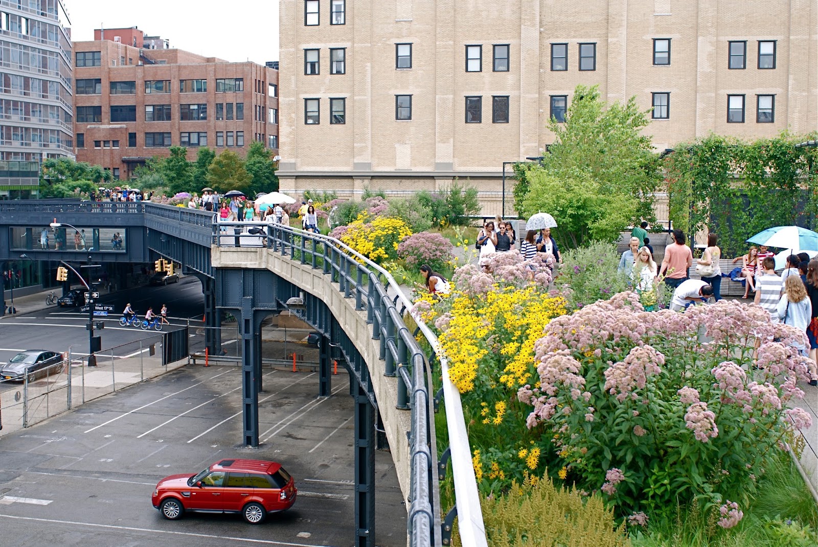
Photo: Rebecca Bellan
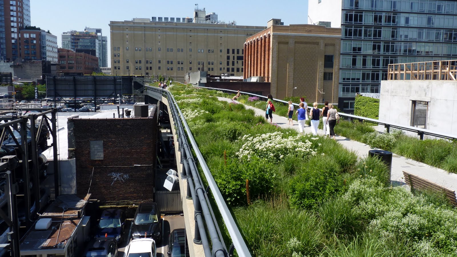
THE HIGH LINE (a.k.a. The High Line Park) is one of the most interesting urbanatural sites of recent years, particularly in New York City. The residents of NYC have taken an old, abandoned elevated railway line and converted it into a gorgeous, functional, almost wild park in the middle of the most “urban” city on America’s East Coast. The HIGH LINE functions like a walk through the wild woods or forest fields that just happens to exist in the middle of Manhattan Island, running from to Chelsea to 30th St. West. In 1999, Joshua David and Robert Hammond–two local residents, began to support the idea that a then-decaying rail line–on which a final train of frozen turkeys (three boxcars worth) had run in 1980–should be saved. Two decades earlier, when the route fell silent, many residents wanted to tear the rusting eyesore down; but–at that time–Peter Obletz, who lived in Chelsea at the line’s southern end–argued in court that demolition would be a local, historical, and wasteful mistake. Then, in 2002-03, their group–“Friends of the High Line”–established the financial feasibility of saving this unique urban treasure, and they announced a competitive “Designing the High Line” project. CSX Transportation then donated the land to the city, and James Corner Field Operations, a landscape architecture firm, Diller Scofidio + Renfro, and Piet Oudolf, planting designer, were selected to begin work on the project.
The High Line Gets “Built”
By September of 2014 the project was finished, and Friends of the High Line enthusiastically acknowledged their decade-and-a-half of dedicated work on the entire project, reaching from Gansevoort Street (the Meatpacking District) to West 30th Street further uptown. The supporters currently claim that this almost perfect example of urbanatural roosting draws in more curious sight-seers and visitors than Lady Liberty on her island to the south of the island. There are currently over 300 plants that are watered and pruned on the High Line, and treated very well here: grass varieties, perennial flowers, shrubs of many sizes, and even a number of tree species that will provide increasingly more shade as the years–and the decades–progress; The High Line is not going anywhere–it will hopefully serve as a model for many such sites in cities throughout North America and, let us hope, the world. No one is allowed on the High Line except walkers and, like its model, the Coule Verte in Paris, the 0ne-and-a-half (1.5) mile–2.4-kilometers–pedestrian pathway offers gorgeous views of the East River and the Hudson River, as well as glimpses of countless interesting buildings on both sides and the streets below; it often links neighborhoods of the city faster than if hikers had taken taxis or their own cars (God forbid such motorized vehicles in a city that rarely needs them: maybe for getting a woman in childbirth to the hospital?). Its West Side vantage point reveals yet another way that downtown features are reclaimable, and that industrial architecture is much more than just recyclable metals.
More valuable sites connected with The High Line:
The High Line Hotel: As The New Yorker tells us–in its 9/22/2014 issue–this Gothic masterpiece “inhabits the former General Theological Seminary, in Chelsea. One late-summer evening, patrons in designer sunglasses lazed beneath gas lamps, slurping oysters and sipping Chandon Brut, or Étoile Brut, or an eight-hundred-and-fifty-dollar magnum of Dom Perignon Vintage Blanc ’04 from large coups.” This hotel was a perfect adaptive reuse–as we used to say in my days at The National Trust for Historic Preservation–of an outmoded theological seminary. It overlooks a beautiful part of the city and is situated so that you can walk the full length of the High Line, up and back, without any effort beyond enjoying all of the growing plants and happy people you encounter. The first time I walked the full circuit, up and back, I saw more smiling New Yorkers that I had ever seen in one place at one time–ever! Urbandaddy.com gives us the details for what they call “the most pleasant outdoor drinking spot in New York” at this fabulous venue: Champagne Charlie’s at The High Line Hotel, 180 10th Ave (between 20th and 21st) New York, NY 10011. 212-929-3888. What could be more urbanatural than that!
BATTERY PARK CITY:
Battery Park City, a reclaimed and urbanaturally designed neighborhood on the southwest side of Manhattan, was completely developed from land excavated during the building of the first World Trade Center Towers (and several other projects), as well as sand dredged out of the New York harbor, in the 1970s. The area was damaged during the 9/11 terrorist attacks but has since emerged as one of the most dynamic areas of Lower Manhattan. It includes 92 acres acres, over one third of which is preserved as natural parkland. Development of the area followed a new model of urban planning, allowing for 36 acres of total open space along with residential development covering 7.2 million square-feet and commercial buildings adding an additional 92 million square feet. The residential buildings include The Solaire, which calls itself “America’s first environmentally advanced residential rental tower.” A LEED Gold structure, it was also the first of New York’s high-rise residential spaces certified by the U. S. Green Building Council: computerized electronics manage the environmental impact of the building, it employs photovoltaic cells for the production of electricity and generates 67 % lower peak energy demand that New York’s building codes require.
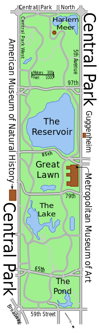
Central Park:

Contemporary Map of Central Park
Central Park is the most frequently visited urban park space in America. While not one of the largest parks in America in terms of land area, it is nevertheless one of the most well known, most often filmed, and most widely beloved among New York City dwellers and visitors over the past two centuries. The winning plan for the park was an original design–“The Greensward Plan”–by Frederick Law Olmstead and Calvert Vaux: “a democratic development of the highest significance,” according to Olmstead, that included 36 distinctly designed bridges, double lines of elm trees leading to the Bethesda Fountain Terrace, and a dramatic combination of woodlands, lakes, paths, and cross-park carriage and automotive traffic routes (as well hidden as possible from the view of the nature-loving public). From the 1875 map (above) to the contemporary north-south view of its well-known features (left), Central Park has served as a a quiet retreat, a perfect lunch spot, a hiker’s venue, and a romantic meeting place for decades. From its original 778 acres in 1857–the year it was founded–to its current 843 acres, the Park has been central in many respects (geographically, psychologically, and romantically) in the minds of most New Yorkers.
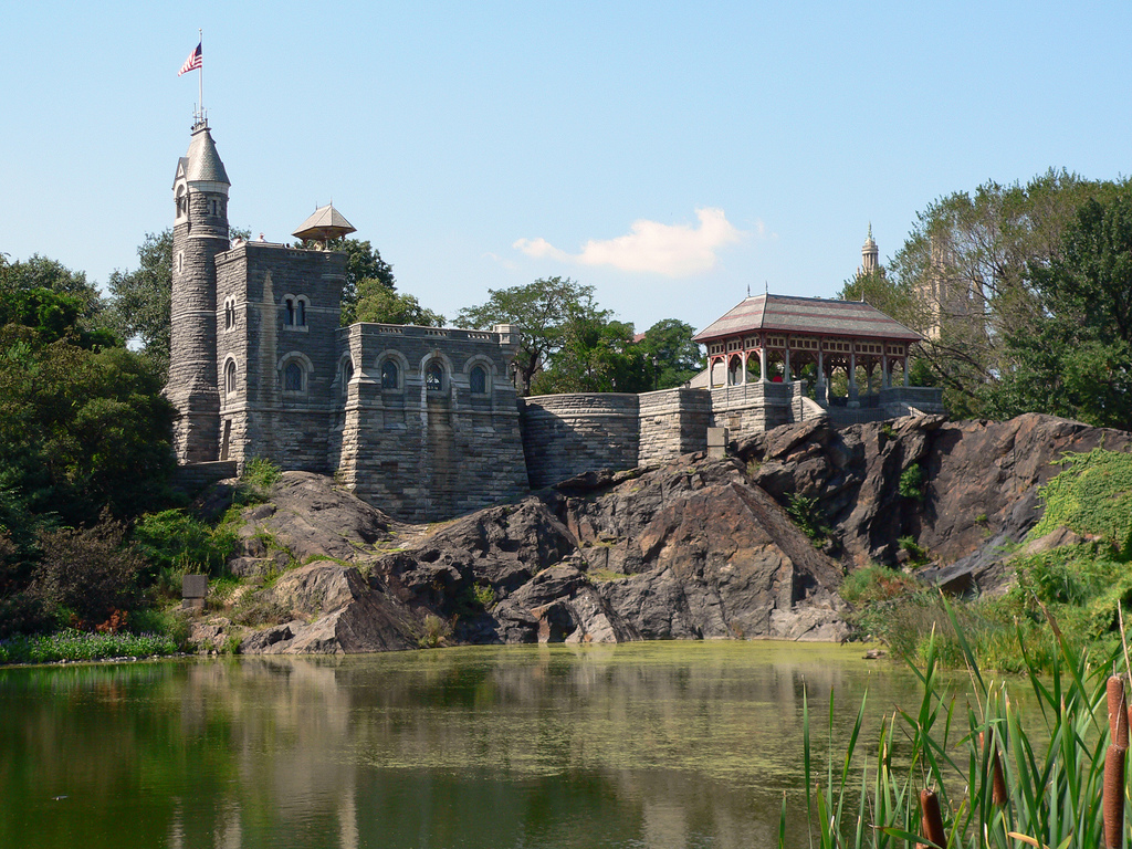
Belvedere Castle Photo: Stig Nygaard
Surprising features inside of the park include: Cleopatra’s Needle (c. 180 tons and 70-feet-tall), an ancient Egyptian obelisk created around 1450 BCE for Pharoah Thutmose III. Two centuries later its hieroglyphic inscriptions honored Rameses II; Strawberry Fields, 2.5 acres set aside and inscribed with the single word “Imagine” to honor John Lennon, former Beatle gunned down by an assassin five years earlier at the Dakota Apartment Building close by on Central Park West; and finally, Belvedere Castle, a Victorian Folly that was a late (1880) addition to the Park by Olmstead and Vaux: the castle now serves as the Park’s official weather station and has also appeared in Woody Allen’s Hannah and Her Sisters, as well as in Sesame Street–where it served as the home of Count von Count (above). Below is a view well-known and beloved by New Yorkers, Central Park taken from high above Central Park South, legendary street that runs from Columbus Circle in the west to the Plaza Hotel in the east, home of Eloise in the classic children’s book, and site of the legendary Palm Court and Oak Bar eatery and drinkery.
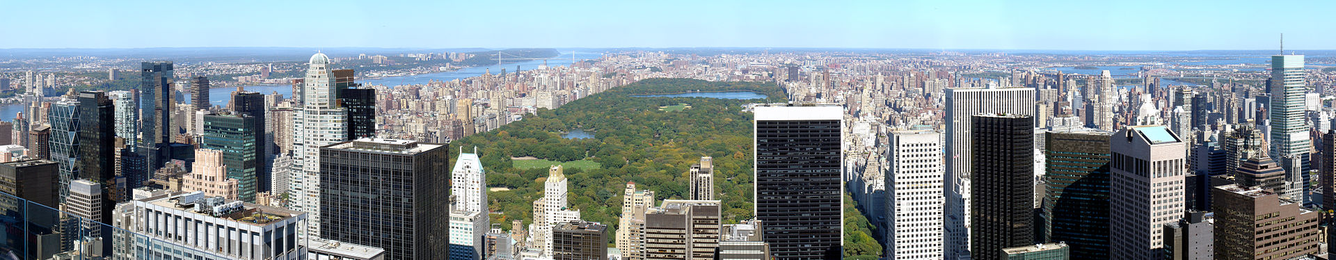
Photo: Martin St-Amant
Urban Hawks:
One of the most obviously urbanatural activities in Manhattan, and also one of those most closely linked to roosting, is UrbanHawks, a group of committed avian naturalists and birders (folks the British often refer to as “twitchers”) who devote countless hours of their time to tracking, recording, and documenting (usually with cameras and videocameras) the raptors of New York City: that is, the hawks, owls, and eagles that populate or pass through eastern North America’s largest urban space. Their website chronicles an amazing series of images and short films of these remarkable creatures as they fly, roost, mate, feed, raise their young, and generally go about the business of living. See, for example:
See the YouTube above for a remarkable video example of the sorts of work done and posted on the UrbanHawks website. These raptor enthusiasts have produced a wonderful archive that will be of use to naturalists and scientists as well as bird watchers and hobbyists.
Hidden Urbanatural Spaces, Parks, and Gardens in NYC
Link to this site–(HIDDEN)–if you are interested in often not well known elements of urbanature throughout the five boroughs. This webpage chronicles a remarkable list of generally overlooked urban treasures of natural beauty, historical significance, ongoing practical function, or a combination of the three. Here are some of the most remarkable sites:
—Queensway: the next possible High Line, Queensway is a 3.5 mile long section of elevated rail line (part of the old Long Island Railroad [LIRR] Rockaway Beach Branch) that has been completely abandoned since long ago 1962. Friends of the QueensWay now would now like to embody the best urbanatural principles to convert this stretch of urban blight into a beautiful and useful park, a new element of the Borough of Queens that will exist for the benefit of residents and visitors of many stripes: hikers, bikers, joggers, walkers and perhaps even botanists, gardeners, and urban foresters. Current visitors–who can find there way in–can already wander through dense underbrush and occasional fauna or clamber around rusting rail lines, overpass bridges, and industrial flora.
—The Elevated Acre: an acre-long piazza connected to 55 Water Street, this clever bit or urbanatural design took an otherwise unused space and transformed it into one of the cleverest of contemporary urban designs. Walkers on the nearby sidewalks beneath the park are drawn by lights, plantings, stairs, and shiny escalators to find out what awaits them one story up above the traffic noise and bustle. Once there, visitors find comfortable bench seating with dramatic views of New York Harbor in one direction and the Brooklyn Bridge in another. This magical acre also offers space that can be used for parties or receptions as well as accommodating an outdoor amphitheater, and even an ice-rick. This small park is part of the long-term project known as the Green Necklace, a series of open and natural spaces that will eventually encircle Manhattan’s edge.
—Staten Island Greenbelt: Having been called “the Adirondacks of the five boroughs,” this area of distinct parks, extensive hiking trails (35 miles in all), and acres upon acres of open space (totaling 2,800) serves Staten Island and the wider metropolitan area as a rich resources of natural, educational, and entertainment facilities. In the High Rock Park, for example, visitors may be able to find some of the quietest and tranquil woods in the entirety of New York City. A native plant center, golf course, recreation center, carousel, and nature center, are just some of the treasured features of this well planned and well supported region. The greenbelt is wild enough to support not only the desires of its human visitors but also the lives of creatures ranging from white-tailed deer, cottontail rabbits, and eastern chipmunks to snapping turtles, American bullfrogs, and even the occasional eastern milksnake.

—The Wycoff House Farm Museum: Who would have thought that there was a farm museum (above) almost in the middle of Brooklyn? One of, if not the oldest house in the city, the Pieter Claesen Wycoff House is a National Historic Landmark, parts of which were standing on its current location in 1652. The museum now operates a functioning garden–growing everything from berries and herbs to a wide variety of vegetables, and eventually even an apple orchard. At the same time, the museum’s primary function is educational; it sets out to documents farm life in the 17th-century and beyond, while also working to demonstrate as many material elements of that life as possible. As the garden’s website notes, “the hope is that the Garden’s most enduring product will be an educated community.”
—The Creative Little Garden: voted the Best Community Garden by the Daily News in May of 2012, this neighborhood green-space was the result of a great idea. Instead of having separate gardening plots for individuals or small groups, the entire if small space (24 x 100 feet) is gardened by the entire if small community of 40 to 80 local residents. The garden is open, however, to all visitors or passersby as a place to sit down, enjoy a rest, and even bring your leashed pet for a few moments of quiet in the often less-than-quiet city, even in the East Village. The Creative Little Garden is located at 520 East Sixth Street, between Avenues A & B. Enjoy!