This ride, while not exactly meeting the length requirements of a Medium ride, certainly meets the terrain one.This route is just over 9 miles.
- Start at the intersection of High St. and College St. Head north on N College Street.
- Turn left onto B Street (Follow the PA 74 North signs). (at .52 mi)
- PA 74 turns into Waggoners Gap Rd. as it passes Carlisle High on the left and Bellaire Elementary on the right, both with large solar arrays. (at 1.11 mi)
- Pass under the Pennsylvania Turnpike and out into North Middleton Township. Follow Waggoners Gap as it crosses the mighty Conodoguinet Creek. After the Creek, make your second left onto Union Hall Rd. (at 2.5 mi)
- This road offers amazing views with its decently sized hills. Follow this for a few miles, passing fields on your right and the Bongiorno Conference Center on your left. (at 3.45 mi)
- Union Hall T’s into McClures Gap Rd, turn right. (at 3.96 mi)
- Turn left on Willow Grove Rd. (at 4.29 mi)
- Before you cross the metal, one lane bridge, turn left onto Meadowbrook Rd. (at 4.95 mi)
- Turn right to stay on Meadowbrook Rd. (5.90 mi) Cross the Creek and the PA Turnpike.
- At the end, turn left onto Newville Rd. (PA 641 East). (at 6.56 mi)
- Follow this for 2 miles until N Orange St. and turn right. (at 8.56 mi)
- Take the first left onto W High Street and head back to campus.
This ride is not that long, but is moderately hilly. Caution is advised on Newville Rd (PA 641) during rush hour traffic.
Click here for the link to the route on MapMyRide.
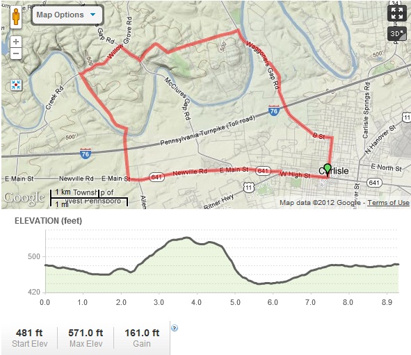
Overview map of the Union Hall Ride