The West Penn route brings riders through West Penn Township and Plainfield, both west of Carlisle. This route is about 15 miles.
- Start at the intersection of W High St. and College St. Begin west on W High St. (US 11 & PA 641).
- At the railroad bridge past the diner, turn right on N Orange St. (at .62 mi)
- Take your first left immediately left onto Newville Rd. (PA 641).(at .65 mi)
- Follow Newville for just under 5 miles into Plainfield. Newville has its share of truck traffic, but only during rush hour does any concern rise. In Plainfield, turn left onto Greason Rd. (at 5.04 mi)
- Follow Greason along its many twists and turns. Turn left onto Barnstable Rd. (at 7.29 mi)
- Follow Barnstable past picturesque farms to its end at Ritner Hwy (US 11). Turn right onto Ritner Hwy (US 11). (at 10.24 mi)
- Turn left onto Shagbark Lane. Be advised, Shagbark is easy to miss, as it is at the bottom of a hill. If you cross a small creek, you’ve gone too far. (at 10.95 mi)
- Follow Shagbark along a creek and under Interstate 81 to a T with Alexander Spring Rd. Turn left onto Alexander Spring. (at 11.75 mi)
- Follow this past the warehouses, Allen Rd (PA 465), and the Carlisle Hospital. At the end, turn left onto Walnut Bottom. (at 11.29 mi)
- Pass I-81, and turn left onto S College St, to return to campus. (at 15.27 mi)
This route is of both moderate length and contains moderate terrain. Be aware of traffic along Newville Rd. (PA 641), Ritner Hwy (US 11) and Walnut Bottom Rd. during rush hour.
Click here for the link to the route on MapMyRide.
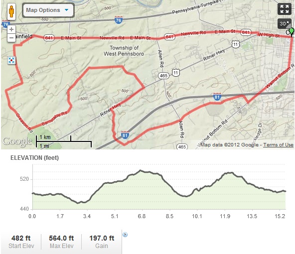
Overview Map of the West Penn Ride