This is a 10.64 mile route.
- Travel south along S College St.
- Turn right onto Walnut Bottom Rd. Follow Walnut Bottom past I-81. (at .6 mi)
- At the first traffic light past the interstate, turn left onto Stonehedge Dr. (at 1.54 mi)
- Follow this through the neighborhood and take your second left onto Forest Lane. (at 1.9 mi)
- Turn right at the T onto Rockledge Dr. (at 2 mi)
- Follow this road for a bit, and then bear right onto Oak School Rd. (Note: there may not be a street sign) (at 2.93 mi)
- Follow Oak School Rd. to the stop sign and continue straight onto Adams Rd. (at 3.89 mi)
- After Adams curves left, you can either continue down & up the hill, or avoid it and turn into the development, which drops you back onto Adams a short while later.
- Follow Adams through the fields and past the dairy farms to the T with Burnthouse Rd. The views around this intersection are some of the best around. (at 5.62 mi)
- Either loop back along Adams or turn right onto Burnthouse. If you do turn right, follow the road until you intersect Walnut Bottom Rd.
- Turn right onto Walnut Bottom and follow this back to the Borough. (at 6.18 mi)
- Turn left onto S College St. (at 10.04 mi)
- Follow this until you find yourself back on High st. (at 10.64 mi)
This ride is easy, with little terrain, and indescribable views. Caution is advised to riders on Walnut Bottom Rd. (PA 465) during rush hour traffic.
Click here for the link to the route on MapMyRide.
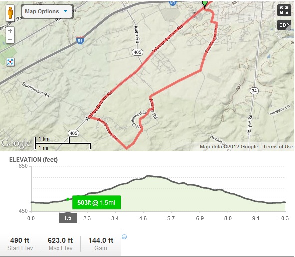
Overview Map of the Adams Rd Ride