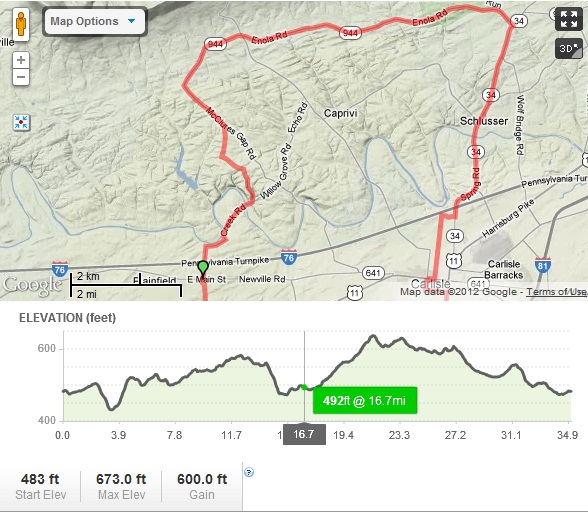
This route brings you across the valley first north to North (Blue) Mountain, then back south to, you guessed it, South Mountain, before returning to Carlisle. This is a long ride without many difficult hills. The route is about 35 miles and has a total elevation gain of 255 ft.
- Start at the intersection of W High St. and N West St.
- Begin north on N West St.
- Follow to the north end of Carlisle, then turn right onto K Street. (at 1.16 mi)
- Go straight through the round-about, and turn left onto Spring Rd. (PA 34 North). (at 1.41 mi)
- Follow Spring Rd. into the village of Carlisle Springs. Turn left onto Enola Rd. (PA 944 West). (at 5.21 mi)
- Follow the base of North Mountain for a few miles, past Waggoners Gap Rd. (PA 74), then turn left onto McClures Gap Rd. (at 11.96 mi)
- Follow McClures Gap for a bit, then bear right onto Mt Zion Rd. (at 12.99 mi)
- Turn left onto Opossum Lake Rd. (at 13.54 mi)
- Bear left onto Campground Rd. (at 13.93)
- Turn right onto Meadowbrook Rd. (at 14.05 mi)
- At Willow Grove Rd., turn right. (at 14.68 mi)
- Keep right across the one-lane metal bridge to Creek Rd. (at 14.82 mi)
- Follow Creek Rd up the hill, then turn right to remain on Creek Rd. (at 15.62 mi)
- At the T, turn left onto McAllister Church Rd. (at 16.01 mi)
- Cross the PA Turnpike and continue across Newville Rd. (PA 641). Follow McAllister Church to its end at Ritner Hwy (US 11). Turn right onto Ritner (US 11 South). (at 18.18 mi)
- Pass the Cumberland Valley Golf Course, then turn left onto Mooredale Rd. (at 19.98 mi)
- Follow Mooredale Dr. to the end. Turn left onto Stonehouse Rd. (at 22.42 mi)
- Turn left onto Walnut Bottom Rd. (at 23.04 mi)
- Immediately turn left onto Monstera Rd. (at 23.20 mi) DON’T TURN LEFT ONTO OLD YORK RD. (PA 174).
- Follow Montsera Rd. across the Norfolk Souther tracks, the Yellow Breeches Creek, then turn left onto Pine Rd. (at 24.50 mi)
- Follow Pine Rd. to its end at the Holly Pike (PA 34). Turn left onto the Holly Pike (PA 34 North) and follow it back into Carlisle. (at 29.83 mi)
- This will eventually turn into S Hanover St. and you will come to the intersection of S Hanover and E High St. (at 34.61 mi)
- Turn left onto E High St. back to campus.
Riders should be cautious along the stretch of Spring Rd. (PA 34) within Carlisle borough, Ritner Hwy (US 11), and the Holly Pike (PA 34) during rush hour traffic times, as well as a warning to pack extra water, as there are few places along the ride to fill up or purchase refreshments.
Click here for the link to the route on MapMyRide.
Overview Map of the Northern 1/2 of the Ride

Overview Map of the Southern 1/2 of the Ride
