This route is a challenge, but is well worth it. This will bring you northeast of Carlisle through the small village of New Kingston and, if you’re up to it, up North (Blue) Mountain. This ride is about 25 miles with one major climb.
- Start at the intersection of S College St. and W High St. Head east, away from campus, until it turns into Trindle Rd. (still PA 641) after I-81.
- Follow Trindle for about 3 miles, and then turn left onto S Middlesex Rd. (at 3.65 mi)
- Turn right onto Ridge Dr. (at 4.04 mi)
- Ridge Rd. will turn into Biddle Rd., after passing Old Stonehouse Rd.
- Cross over the PA Turnpike and turn immediately right onto Kost Rd. (at 6.56 mi)
- At the T, turn left onto Locust Point Rd. (at 7.46 mi)
- Pass through New Kingstown and across the Carlisle Pike (US 11) and remain on Locust Point across I-81. Turn left onto Green Hill Rd. (at 9.94 mi)
- Turn right onto Bernheisel Bridge Rd. (at 10.51 mi)
- After you cross the Conodoguinet, you’ll pass a parking lot, which can be used to access the Appalachian Trail if you’re interested. (at 11.35 mi)
- Continue north on Bernheisel Bridge to its end at Wertzville Rd. (PA 944). (at 13.57 mi)
- If you’re not interested in climbing North Mountain, turn left then immediate left again to follow Wertzville Rd. (PA 944 West) to Spring Rd. (PA 34).
- If you’re interested in the climb and the views it offers, turn left then stay straight on Sunnyside Drive. (at 13.64 mi)
- This is a climb, and Sunnyside has a decent amount of traffic around rush hour, so be very aware of vehicles and trucks coming up behind you. Follow Sunnyside up until you reach Sterretts Gap and JCT Spring Rd (PA 34). (at 14.74 mi)
- Take in the views, cross into Perry County for a bit, and then turn left onto Spring Rd (PA 34 South). (at 14.83 mi)
- Mind your brakes and your speed going down the hill. Follow Spring Rd. back into Carlisle. Once you cross under the PA Turnpike, turn right onto K Street. (at 21.23 mi)
- Pass the circle and the convention center, curve left and follow West St. back into campus. (at mi 21.49)
- You will come to E High St. (at 22.65 mi)
This route is of decent length, and, if you choose to do so, has a long climb at the end. The route outside of the mountain is rolling with some hills, but nothing beginning riders can’t handle. Caution is advised to riders traveling on Trindle Rd./E High St. (PA 641) during rush hour, as well as extreme caution on Sunnyside Rd. If you’re on Sunnyside and traffic is getting too much for you to handle, just get off your bike and wait out traffic spells on the side of the road. Otherwise, enjoy the views from the mountain and the views from the rest of the route!
Click here for the link to the route on MapMyRide.
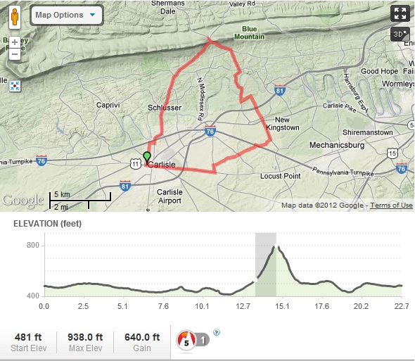
Overview Map of the New Kingstown & Sterretts Gap Ride
