Month: April 2018 (Page 4 of 7)

The Travels of Marco Polo: Medieval Map and Analysis

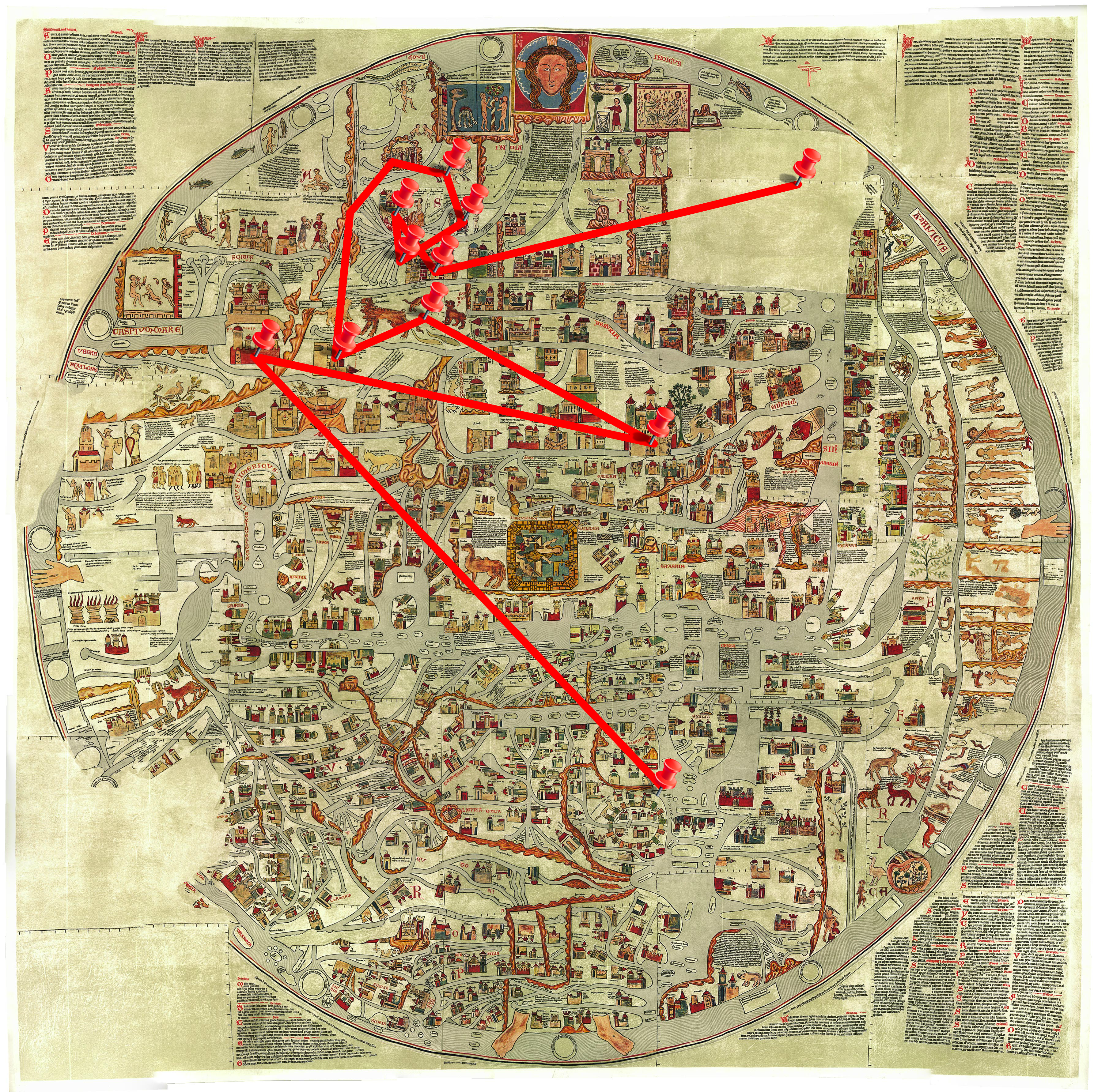
Many of the places that Polo discusses past the middle east are not visible on the Ebstorf map. Since the creator of the map resided in a monastery in Germany, they might not have had the proper source information in order to depict Asia as the vast continent it is. Instead, halfway through the landmass that is Asia, we begin getting illustrations of wonders and other religious points, such as the garden of eden. Armenia is located so far eastward, that there are no distinct representations of the Great Khan’s cities. The map would not have been useful for Polo’s travels, as it would have turned him around, however it would have been interesting to watch as monks and other map-makers attempted to make sense of Polo’s journeys. The choice to underplay the Great Khan’s power and territory could have been circumstantial – as those residing in Germany did not border his ever-growing empire the same way that Italians did – or it could have been a political choice.

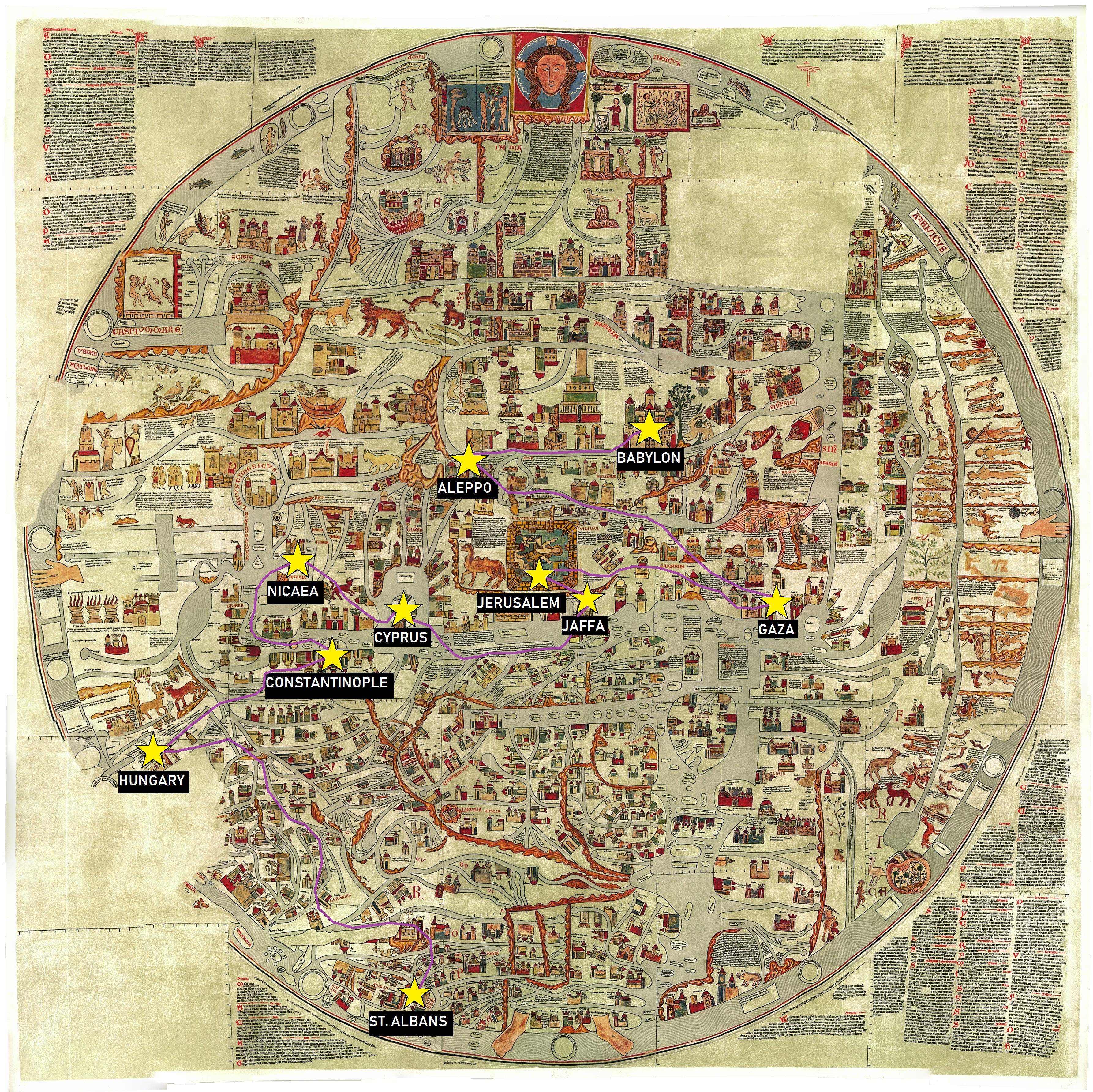
Polo’s journey begins in Venice, marked by the point outside of Rome, given that that peninsula is meant to represent Italy. Rather far towards the upper-left corner of the map is a little island labeled Armenia. Here is the point for Ayas, the city that Polo describes as a gateway to the rest of Asia. Given that on this map it is rather far past the red title of Asia, the creator of this map did not agree. Back towards the center of the map is Baghdad. This markers location was chosen due to the size of the building marking this city, and its proximity to Syria, Assyria, and Arabia. Continuing to the oasis city of Talikhan, the marker is placed in unidentified land, farther east, near a mountain range, in which several beasts reside because the short description of Talikhan that Polo provides indicates that it was a smaller, less frequented city that was useful for re-supplying and a bit of trade, but not much else. Kara Khoja, the desert city that Polo travels through while crossing the Taklamakan, is marked nearby on its own island, as it would have been large enough to still gain recognition, and would have been close to other desert locations, moving towards the direction of “Asia” in general. The point marking Chagan-nor is in the upper-left corner of the map where there were several depictions of birds. Before visiting the Great Khan’s royal city in the Northeast of Asia, Polo stopped in the land of Prester John, therefore the location of Chagan-nor would need to be somewhere east enough to only be a few days ride from the kingdom of Prester John. From Chagan-nor we travel Southward in actuality, but west-ward on the map to a depiction of a king sitting upon a throne to indicate Khan-balik. The river parting around the image, mirrors the canal system of the actual city. The point representing Tandintu, in Cathay, has been placed along one of the many rivers on the way from Khan-balik to Kinsai, as the town was predominantly known for trading along the river. Kinsai is marked nearby by the large city-marker along another tributary river. Kinsai, now Hangzhou, was known for its canals, bridges, and lakes, which made it the most beautiful and prosperous city in Southern China. We circle back around to what could be the coast, given the river depicted travels from Northern Asia through India, to the southern seas, where there is a large city marker that is possibly Fu-chau – the city from which Polo departs Cathay and the Great Khan’s realm, and travels into Southeast Asia and the Pacific Islands. Finally, the point for Java has been placed in the section of the map that was lost over time, as none of the islands past the the red title of “India” were significantly larger than the others before reaching African nations.

The map demonstrates the confusion of Asian geography at the time of Polo’s travels. While a merchant would have had access to more accurate information, the inability of T-O maps to translate actual distances or locations explains a lot of fears about traveling. The map’s spacial understanding of the world is lacking, and many points had to be approximated, however it provides insight to what a great task Polo’s adventures would have been viewed as. The journey from Venice to Armenia alone looks incredibly far and difficult. The beasts illustrated in the deserts demonstrate the fear of lands that Europeans did not know much about. The depiction of the Great Khan as something resembling a European King shows the desire of Europeans to believe that the Great Khan was truly just and would not attack them.

The Book of John Mandeville: Medieval Map Analysis

Transferring points and routes described in Sir John Mandeville’s Book of Marvels and Travels from a modern map to a medieval map posed unique challenges. Given the difficult-to-discern text on the medieval map and major differences in geographical thinking that went into its creation, locating the points themselves required much greater effort than simply typing names into a search bar on the GIS map viewer. Most location names were impossible to read on the image of the map itself, and medieval geography confused things further, with Hungary being placed northeast of the British Isles.

The two final images ultimately highlight the differences between past and present visualizations of the world. The past visualization in this case refers to that of medieval Western Europe. This worldview differs in obvious geographic ways from the modern map. To begin with, the Ebstorf mappamundi that I used to map my points is oriented with the East facing up and depicts only Europe, Asia, and Northern Africa. In addition, the city of Jerusalem is placed prominently in the center, being one of many symbols on the Ebstorf map that indicate the vital importance of the Christian religion in medieval European conceptions of the physical world. It is interesting that some locations appear closer together on the medieval map than they do on the modern one, while others appear to be similar distances on both. This is true even when one zooms in on the modern map to include only the scope of its medieval counterpart.

Centuries of scientific development went into the modern map I was working with. As a result, its geography is highly accurate and it encompasses much more territory of the physical world than what medieval Europeans knew existed, making the journey I mapped seem smaller in comparison. However, the details on the Ebstorf map communicate much more about how the journey Mandeville describes would have been conceptualized in medieval times. Its illustrations, text inscriptions, and wealth of religious symbols say that this is a journey pertaining to the aims of pilgrimage, and that it covers a significant portion of the known world. The modern map communicates more about the realistic aspects of the routes this journey requires, while the medieval map provides an extensive cultural context to the journey.

The Itinerary of Benjamin of Tudela: Map Analysis

After mapping Benjamin of Tudela’s route on both a modern map and St. Beatus of Liebana’s Mappa Mundi, there are some clear differences between the two maps and cartography of each time period. The most obvious difference between the modern map and Beatus map is that the Middle East and Asia are at the top of the Beatus map. There is a depiction of Adam and Eve in the Garden of Eden accompanying these locations at the top of the map because Earthly Paradise was supposed to be somewhere in the “unexplored” areas of the East.

The style of the Mappa Mundi is a T and O map meaning, representing only one half of the Earth. One would notice that only Europe, the Middle East and parts of the Asian and African continents are pictured. The ‘T’ represents the land, and the surrounding ‘O’ represents the water surrounding it. Jerusalem is strategically placed in the middle of St. Beatus’ Mappa Mundi due to its religious significance for Christians, Jews, and Muslims alike.

The Beatus Map is, however, written in English, which is interesting because it was written by a Spanish monk, St. Beatus of Liebana based upon accounts from St. Isadore of Seville, Ptolemy, and the Bible. This map’s purpose was not to be exactly accurate (which it was not going to be due to the West’s knowledge of the rest of the world) but to depict the Diaspora of the Apostles.

When examining Benjamin’s travels on both the modern map and the Beatus Map, they do look similar in comparison, just flipped. With the exception of the far east, all of Benjamin’s travel locations do appear on the Beatus Map. It makes sense that, although oriented differently from the modern map, and despite the T and O style layout, most of Benjamin’s locations are accounted for. This is because The Beatus Map was arguably the most important map that came out of the Early Middle Ages. Benjamin also traveled mostly in the West and Middle East, so most of the locations are present in the Beatus Map.

Looking at these maps and all of the locations to where Benjamin traveled, it is difficult to believe that he did, in fact, travel to China, Tibet, and  India with few stops along the way. Benjamin gives fairly detailed accounts for numerous locations throughout Europe, the Middle East, and Africa. There is a stark contrast between those accounts and the accounts of his “travels” in the far east. Especially because the Beatus map was a prominent map during the time of Benjamins travels, the fact that it does not depict India and East Asia would cause one to believe that he did not actually travel there.

« Older posts Newer posts »

© 2024 Mapping the Global Middle Ages


Academic Technology services: GIS | Media Center | Language Exchange

Theme by Anders NorenUp ↑