Category: John Mandeville (Page 3 of 7)

The Book of John Mandeville: Constantinople 

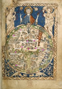
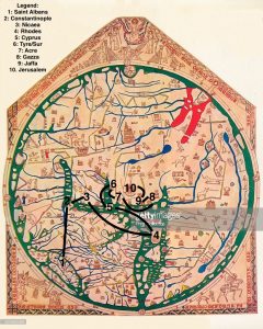
Mandeville is especially concerned in this section with the religious history and religious significance of Constantinople. He writes at length about relics that are housed there, including the sponge and reed which Jesus drank from on the cross, one of the nails that held him to the cross, and part of the crown of thorns which he wore as he died (8-10). He also writes about saints who were buried in Constantinople, listing St. Anne, St. Luke the evangelist, and St. John Chrysostom. It seems that he wants his readers to know the fullest extent of Constantinople’s religious heritage, and he picks back up on this a few pages later when he talks about religious differences between Greek and English Christians.

Mandeville also writes about buildings, discussing the Emperor’s palace and drawing attention to its beauty. He claims the palace “is really lovely and beautifully adorned” and notes its practical design features as well as the aesthetic elements, stating that the Emperor’s stables were built underneath tiered seats in a jousting court (using space that may otherwise have been wasted) and that the stables’ pillars were made of marble (12). He draws attention to the wealth of Constantinople through these details, as well as when he describes the geography; he writes that “Constantinople is a very beautiful and great city with strong walls and it is three-cornered” (11). Mandeville seems to make a connection between wealth, beauty, and political strength by listing beauty, greatness, and strength as equal descriptors of the city, and echoes this sentiment when describing the Emperor’s palace.

Mandeville links beautiful buildings with religion in his description of St. Sophie’s church, which he calls “the finest and most beautiful church in the world” (8). He continues to describe a statue of the Emperor Justinian in front of the church. Here Mandeville slips from describing what he sees to reporting what people tell him: he presents a legend about this statue, explaining that it used to hold an apple which represented the emperor’s political power. Mandeville claims that “people have tried many times to put the apple back into the statue’s hand again, but it will not hold it; this apple signifies the lordship he once had over the world” (8). This moment is interesting to me in its intersection of politics and religion; not only does a statue of an emperor stand outside of a church, but the symbolism of a fallen apple reminds me of the fall of Adam and Eve in Christian mythology. I wonder if Mandeville is making an implicit connection that his contemporary readers would have picked up on.

Mandeville states his purpose in recording “things [that] are not relevant to the journey” at the end of this chapter, after he spends three long paragraphs describing the ways Greek Christians differ from English Christians in the ways they practice their faith (13-14). He claims he wants to show his readers differences in faith and culture for entertainment purposes, arguing that “many people take great pleasure and comfort to hear talk of unfamiliar things” (14). This points both to his purpose in writing and what his audience would have found unusual; Mandeville provides an impressive list of the differences in Greek Christianity compared to the Christianity of his readers (13), giving the impression that these details would provide a kind of shock value to his audience.


(pp. 7-14)

The Book of John Mandeville: Medieval and Modern Map Analyses

Sir John Mandeville’s journey is significantly different visually when plotted on the Hereford Mappa Mundi rather than a modern map. Most obviously, because the Hereford Mappa Mundi is oriented with east on top of the world, Mandeville seems to be traveling up and to the right rather than down and to the right. The route plotted on the modern map seems impractical and even nonsensical, in large part due to Sir John Mandeville’s misunderstandings of geography. Once plotted on the Hereford Mappa Mundi, which contains even more geographical mistakes itself, the route which is supposed to be one of the best ways to Jerusalem seems even more ridiculous. Both maps have several places where Mandeville seems to double back on himself or make a small loop, but on the modern map the loop takes place in the coastal cities of Syria and Israel, most likely due to Mandeville’s misunderstanding of how the cities are ordered down the coastline. However, on the Hereford Mappa Mundi, not only does John Mandeville not know where some of the locations he claims to have visited are located, but the map’s author does not know either. Most obviously, the labyrinth on the map that represents the island of Crete (where John Mandeville describes visiting Rhodes) is drawn much too far south in the Mediterranean, nowhere near Greece or Turkey. The island of Cyprus is not labeled at all, so I chose a larger island close to where it would realistically be located based on the modern map and called is Cyprus. I did the same with the coastal towns and cities of Syria and Israel, labelling them along the coast as closely as possible to where they were located on the modern map. The Hereford Mappa Mundi also did not have Saint Albans or Nicaea on the map, so I set them in the middle of England and Turkey, hopefully close to where they might be located. Overall, however, the Hereford Mappa Mundi is surprisingly accurate for the time. Sir John Mandeville’s ridiculous route looks very similar on both the medieval and modern map.

The Book of John Mandeville Medieval Map

In the beginning, mapping the first place from John Mandeville’s narrative onto the Psalter World Map, was actually relatively easy. One of the reasons that I chose the Psalter map was because it included a small part of England which the author claims as his home country. The inclusion of England in the map is unusual so it was easy to find because most of the historical sources I used pointed specifically to this distinction. My second point, Constantinople, was harder to find because the labeling on the map is difficult for me to read. I was able to find “roma” and from there located “grecia.” Then, comparing the waterways on the medieval map that seemed to be the Mediterranean Sea and the Black sea to where they are on the world map we know today, I tried to accurately guess where Constantinople would be. Luckily, my third point, Jerusalem, was even easier to find than England, because it’s in the center of the map and clearly labeled, but Damascus was harder because there was no label that I could read that resembled it or anything near it. I knew it was near Jerusalem and on the other side of the body of water from Constantinople but I just had to guess from there. I knew that Africa was supposed to be towards the bottom right of the map, so I looked closer to that side for Babylon. I found a label that I think says Babylon in that area, so I placed it there. For Gaza I tried to employ the same strategy I used for Constantinople. I compared where the Red Sea was on the Psalter Map to where it was on today’s map, and using Jerusalem and Babylon as fixed points, tried to guess where Gaza would be.

However, once I got those first six points down, the rest of the places I mapped in my modern map were almost impossible to map in the second. East of Jerusalem on the Psalter Map seems to be made up of nothing but illegible labels and the way to Paradise. The only way that I was able to even try to guess where my last points were on the map was knowing that it was a flipped version of the map that I was used to, with east at the top, and drawn in a “T” shape, with all of Asian taking up the big side of the t. Again, I tried to compare it with the real map of the world, and guess where the four remaining points would go if the Psalter map were similarly constructed. Overall the mapping got incredibly difficult the farther east the points went. This shows how little the medieval people actually knew about what was East of Jerusalem. They had no idea how big the area of Asia or Russia was, or where anything was located. This reflects how John Mandeville’s narrative proceeds East as well, because he seems to not know where anything is actually located when he describes India and Asia.

Psalter World Map

The Book of John Mandeville: Medieval Map Analysis

Transferring points and routes described in Sir John Mandeville’s Book of Marvels and Travels from a modern map to a medieval map posed unique challenges. Given the difficult-to-discern text on the medieval map and major differences in geographical thinking that went into its creation, locating the points themselves required much greater effort than simply typing names into a search bar on the GIS map viewer. Most location names were impossible to read on the image of the map itself, and medieval geography confused things further, with Hungary being placed northeast of the British Isles.

The two final images ultimately highlight the differences between past and present visualizations of the world. The past visualization in this case refers to that of medieval Western Europe. This worldview differs in obvious geographic ways from the modern map. To begin with, the Ebstorf mappamundi that I used to map my points is oriented with the East facing up and depicts only Europe, Asia, and Northern Africa. In addition, the city of Jerusalem is placed prominently in the center, being one of many symbols on the Ebstorf map that indicate the vital importance of the Christian religion in medieval European conceptions of the physical world. It is interesting that some locations appear closer together on the medieval map than they do on the modern one, while others appear to be similar distances on both. This is true even when one zooms in on the modern map to include only the scope of its medieval counterpart.

Centuries of scientific development went into the modern map I was working with. As a result, its geography is highly accurate and it encompasses much more territory of the physical world than what medieval Europeans knew existed, making the journey I mapped seem smaller in comparison. However, the details on the Ebstorf map communicate much more about how the journey Mandeville describes would have been conceptualized in medieval times. Its illustrations, text inscriptions, and wealth of religious symbols say that this is a journey pertaining to the aims of pilgrimage, and that it covers a significant portion of the known world. The modern map communicates more about the realistic aspects of the routes this journey requires, while the medieval map provides an extensive cultural context to the journey.

« Older posts Newer posts »

© 2024 Mapping the Global Middle Ages


Academic Technology services: GIS | Media Center | Language Exchange

Theme by Anders NorenUp ↑