Category: Margery Kempe (Page 4 of 6)

The Book of Margery Kempe: Modern vs. Medieval Map

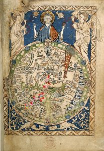
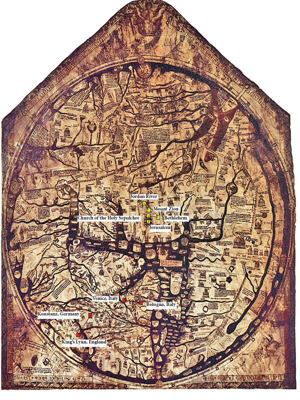
Despite the glaring differences between the modern, online-created map being oriented North, and the Medieval hand-drawn Psalter Map being oriented East, the biggest difference between the two that I noticed was a lack of temporal/spatial awareness on the Psalter World Map. Once I plotted the points from the Modern Map onto the Psalter World Map, I realized that it was inaccurate in terms of spatial awareness. For example, on the Psalter Map, the entire peninsula of modern-day Italy is especially cramped and walled off by the Alps. This made me plotting Bologna, Venice, and Rome seem in much closer proximity than when I was plotting them online through ArcGIS. I also thought this was interesting as I thought it might suggest how medieval travelers saw the Alps as a very treacherous natural boundary to cross. On the same note, England was also exceedingly cramped, making my plots for Norwich and Yarmouth seem way too close to the spot where London was already marked on the map. The Psalter World Map is also incredibly small and, while very detailed for its size, this presents two problems when trying somewhat accurately plot modern points: 1) When trying to plot a city on such a small and cramped map, you end up accidentally covering other markers. This was an issue not encountered when working with the online ArcGIS system, because through internet mapping agents, you are able to pinpoint with startling accuracy and make the points as small as needed so that you do not overlap other important information. 2) Since the Psalter World Map only has space for the things it deems most important, it is not very detailed. I could not find Venice, Bologna, Norwich, Yarmouth, Ramleh, or the Church of the Holy Sepulchre as there simply is not room to detail every specific city or site pilgrims may pass through. In this way, navigating with the Psalter Map is very much a guessing game, speaking to the struggle medieval travelers had when trying to navigate from place to place. This was strikingly different from navigating ArcGIS, as all I had to do was enter the city or even a specific building or address, and it would take me to its exact location. There was no need to guess or even think about it as much.

Another large difference I noticed is that just as we can deduce how ruling cultures think about the world through map orientation (modern day maps are oriented North, placing more value on Europe and the United States as they are at the ‘top’ and near the center. Medieval maps are centered towards the ‘East’ where Paradise is meant to be, and Jerusalem is at the center), one can also deduce from medieval maps what traveling members of society cared about most based on how large a certain city or point is. This is exceedingly evident with the Psalter World Map’s placement of Jerusalem. Not only is is placed in the center, as it is in most T-O maps, which signifies it as the heart of the world and a treasured place around which Christ is said to have lived and died, but Jerusalem is HUGE compared to other cities and is circled, like a bulls-eye. The sheer size of how the city is portrayed screams that in the Middle Ages Jerusalem was considered a VERY important place, and details just how central it was to religious pilgrimage. The fact that the city is circled like a bulls-eye makes it appear the Jerusalem is the “end point” despite paradise being far up to the East.

The Book of Margery Kempe: Medieval Map

The template used is that of the World Psalter Map. You can find the original image here. The below image may appear blurry but upon clicking and magnifying, becomes clear. Edits courtesy of 3D Paint software.

Key:

Yellow/Gold= Religious Sites

Blue= Port Cities

Red= Checkpoints

Purple= Food

  1. Norwich, England
  2. Yarmouth, England
  3. Zierikzee, Netherlands
  4. Constanz, Germany
  5. Bologna, Italy
  6. Venice, Italy
  7. Church of the Holy Sepulchre, Jerusalem
  8. River Jordan, modern-day Israel
  9. Venice, Italy
  10. Rome, Italy

The Book of Margery Kempe: Venice on Margery’s Return Trip

After Margery Kempe travels to various Holy Sites in Jerusalem, she travels back to Ramleh in modern-day Israel, where she then boards another boat and returns to Venice. Ramleh on the West Bank is 2, 203 miles from Venice.  Assuming that most boats around the time traveled at 5 knots, or approximately 5.7 miles per hour, this journey would have taken approximately 16 days, a bit over two weeks. Margery does not speak much about Ramleh, other than remarking that she wishes already “to return again to Jerusalem” (111). The pit stop she describes in Venice is predicated upon the supposition that God has ordered Margery to go to Rome. As a result, she does not focus much on any architecture or cultural points of the city, but focuses on promises God has made to her and deeply describes people who help or hurt her during her endeavors.  On the boat ride to Venice, many of Kempe’s companions are ill, but God assures Margery that no one on the journey will die, which ends up being true. God tells Margery that he will ensure that she makes it to Rome safely, and that when He does, Margery must wear white in Rome as she did in England. While in Venice she finds a broken-backed man in his fifties from Ireland whose name is Richard. Margery then recalls that the anchorite Julian of Norwich told her that when her companions have forsaken her, “God will provide a broken-backed man to escort you wherever you want to go” (112). Richard agrees to accompany her for the price of two nobles. Right outside of Venice, the couple stumbled upon two Grey Friars and a lady who had been traveling with Kempe in Jerusalem. The lady had a donkey with a chest containing an image of the Lord that caused Margery many tears whenever she saw it. At Richard’s urging, Margery set out with the lady and Friars, who treated her well and fed her well, and Richard came to bring her cheer every evening and morning.

When God requests Margery wear white after making it safely to Rome, Margery remarks that the “world should wonder at her” but that she would follow God’s command out of love for him (112). From this statement we can deduce that it is strange in medieval culture for a woman of Margery’s status to wear white. Margery is a strange enough case in and of herself for traveling unaccompanied while still being married. However, white clothing in the Middle Ages was also a symbol of purity and innocence. During this time, cloistered virgins were the only members of society who were socially permitted to wear white. The world would likely wonder and be ashamed at Margery for wearing white because she is not a virgin. Having given birth to 14 children, Margery is very far from being considered a virgin. By wearing white, Margery may wish to demonstrate to society that she is a woman of virtue. Wearing all white not only allows Margery to align herself with the holy virgin women she wishes to emulate, but also displays her conversion into a chaste woman to the world.  The fact that God proclaims her to wear white gives authority to her action.  The Middle Ages are not best known for their sanitation efforts, so white clothing is also impractical for essentially all classes of women. But besides impracticality, it symbolizes a strict adherence to spiritual values. This is made clear within the Bible in Matthew 26, where all the inhabitants of heaven are described as being clothes in white. God giving a command for Margery to wear white allows Margery to emphasize that God believes she is pure and holy and wishes for her to display that to the world. This functions to align Margery not only with virgins on Earth but with the company of heaven. The fact that the command is a dictate from God allows Margery to avoid any legal or societal punishments that may incur for her wearing the color.

Thank you for being understanding of my English Thesis and Political Science Honors thesis deadlines last week and this week. It’s been super busy 🙂


The Book of Margery Kempe: Medieval Map Explanation

When I transferred the points of Margery Kempe’s pilgrimage from a modern to a medieval map, I noticed several differences. Firstly, the modern map was interactive and highly detailed. Because it was online, I could locate very specific locations like Mount Zion or Bethlehem while also zooming out to see the route as a whole. This mapping feature is new within my lifetime, not just a change from the Middle Ages, and it has changed how we interact with maps in the present day. We no longer need to read maps, but can instead type city names into search bars. This made it much more difficult for me to locate places on the Hereford Mappa Mundi. Because it is a map of the entire world, the map lacks detail. What details it does have are very difficult for me to make sense of because even the highest quality images of the map do not preserve the writing very clearly. In addition, I do not read Middle English, and can barely decipher the writing anyway. Because of this, I had to use the basic shapes of places on the map to locate approximate points in Kempe’s pilgrimage.

The process of locating points by geographical shape was also complicated. Unlike the modern maps I am accustomed to, the Mappa Mundi places East at the top of the map, and centers on Jerusalem. This meant I had to reorient my thinking to make sense of the continental shapes. In addition, the continents are greatly compressed, and Africa is an entirely different shape than on a modern map. I found myself working in generalities, guessing the approximate locations of cities. I believe this relates to the medieval experience of travel. Although travellers like Kempe would not have been using maps like the Mappa Mundi for navigation, their knowledge of the terrain and routes of their travel would have been vague at best. Without detailed maps or GPS navigation, Medieval pilgrims would have most likely imagined the bird’s-eye view of their travel as a vague progress towards the Holy Land, if they imagined it at all.

Lastly, the T-O structure of the map, with Jerusalem at the center, reveals the centrality of the Jerusalem pilgrimage to Medieval Christian life. On the modern map, Kempe’s travels create a diagonal zig-zag across Europe and into the Middle East, proceeding down and to the right. On the Medieval map, however, she proceeds directly up to the center of the world. Her journey even appears straighter due to the slight squashing of the Mediterranean. Her journey becomes an ascent towards the walled heart of the world.

« Older posts Newer posts »

© 2024 Mapping the Global Middle Ages


Academic Technology services: GIS | Media Center | Language Exchange

Theme by Anders NorenUp ↑