Page 26 of 39

The Itinerary of Benjamin of Tudela: Medieval Map Analyzed

Upon mapping 10 points of Benjamin of Tudela’s journey on a modern map, and then re-mapping the same points on the medieval Tabula Rogeriana map, one can’t help but notice the similarities between both routes. From first glance, the Tabula Rogeriana map appears to be incorrect geographically-speaking: what we consider to be North today is depicted as the opposite on this map and the ratio between land and sea is disproportionate. Yet, if one were to rotate the Tabula Rogeriana map to be upside-down, or rather right-side up for modern day viewers, Benjamin’s route appears to be almost identical to that which was mapped on a modern map. These points were extremely difficult to find given that the Tabula Rogeriana map was written in Arabic. That said, it was more manageable to find all of my points by first finding larger cities such as Mecca and then Jerusalem and then reorienting myself based on the location of those cities. 

What is different however, is the detailed layout of the land on the Tabula Rogeriana map. It would make sense that the outskirts of the Tabula Rogeriana map are not correct as little to no medieval travelers treaded so far North, East and South, but it is similarly clear that the lands more populated at the time were not thoroughly traveled nor documented either. This would account for the bizarre and misshapen outlines of the countries surrounding the Mediterranean Sea. 

For instance, when looking at the Tabula Rogeriana, Rome and Istanbul appear to be located in their rightful places, but the land that separates them is not. It is known from Benjamin’s travel narrative that he traveled first from Rome to Greece, and then Greece to Turkey, crossing the different bodies of the Mediterranean Sea along the way. Yet, if one were to consult the Tabula Rogeriana instead, it would appear that Benjamin travelled from Rome to Turkey simply by remaining close to the shorelines on his left and not by crossing through the ocean that separates Italy from Greece. 

Furthermore, when comparing Benjamin’s route on the Tabula Rogeriana map and on the modern map, the two routes are very similar. It should also be noted that the cities Benjamin traveled to were relatively close in distance and his route on the Tabula Rogeriana map seems to form a logical loop from Rome to Alexandria —which was back towards where he had started. Like on the modern map, the Tabula Rogeriana map reveals (through the green labeling of water and the blue/white squiggles of ocean) that Benjamin was indeed traveling by boat through water-ways to reach each of the locations he documented having travelled to. This leads me to question the verity of this account of having traveled eastward towards Tibet and China, however the water-ways marked on the Tabula Rogeriana map would still support this route. 

In conclusion, if Benjamin really had travelled all the way out to Tibet and India before heading back towards Alexandria, Egypt, the Tabula Rogeriana map would still have been able to guide him toward the places he sought to visit. Regardless of the medieval map’s errors, the demarcations of land and sea relative to the locations Benjamin traveled to were relatively accurate.
The Travels of Marco Polo: Java

When talking about the Pacific islands, it is hard to tell which ones Polo actually traveled to, as he always describes their distance from Chamba – the port in Southeast Asia – and discusses how one “would get there.” However this vague language can be seen in relation to many of the other locations that Polo travels to, and he often provides distances between lands and the time it would take to get there to aid in understanding the voyage, whether he personally visits the location or not. For the journey to Java, Polo writes that “from Chamba a traveller who sails south-south-east for 1,500 miles comes to a very large island” (Polo, 251). The specific measurements lead one to believe that Polo made this journey, since he would most likely be unable to ask the sailors for the distance in Chamba.

Polo is awed by the island and for the first time besides his description of Japan, the reader is presented with a kingdom that the tartars could not overpower: “And I assure you that the Great Khan has never been able to conquer it, because of the long and hazardous voyage that must be made in order to get there” (Polo, 251). After countless accounts of the tartar’s strength and the Great Khan’s influence, the mention of regions powerful enough to exist outside of the empire is shocking. However Polo’s association of merchants, spices, and other goods with that power is unsurprising. “It is a very rich island, producing pepper, nutmegs, spikenard, galingale, cubebs, and cloves, and all the precious spices that can be found in the world. It is visited by a great number of ships and merchants who buy a great range of merchandise” (Polo, 251). Merchants willingly traveling a far and dangerous route that the Great Khan himself is unwilling to travel creates a perspective of merchants as strong and courageous in a way that the greatest ruler in the world at the time was not.

In a more technical sense, when talking about Java, Polo demonstrates mathematical accomplishments of those who travel. Polo mentions that Java is the largest island in the world, “having a circumference of more than 3,000 miles” (Polo, 251). Assuming that the circumference is reference to the length of the shoreline, Java’s size is one-third of the actual largest island in the world, as Australia is about 9,000 miles of shoreline. In order to comment on the length of the shoreline, Polo would have had to have asked sailors or other experts. Knowledge of the length shows advancements in measurement and geography given that an individual measuring the exact length of the island along the beaches in unlikely.

The Book of Margery Kempe: Medieval Map Explanation

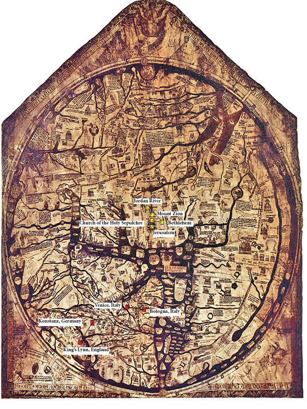
When I transferred the points of Margery Kempe’s pilgrimage from a modern to a medieval map, I noticed several differences. Firstly, the modern map was interactive and highly detailed. Because it was online, I could locate very specific locations like Mount Zion or Bethlehem while also zooming out to see the route as a whole. This mapping feature is new within my lifetime, not just a change from the Middle Ages, and it has changed how we interact with maps in the present day. We no longer need to read maps, but can instead type city names into search bars. This made it much more difficult for me to locate places on the Hereford Mappa Mundi. Because it is a map of the entire world, the map lacks detail. What details it does have are very difficult for me to make sense of because even the highest quality images of the map do not preserve the writing very clearly. In addition, I do not read Middle English, and can barely decipher the writing anyway. Because of this, I had to use the basic shapes of places on the map to locate approximate points in Kempe’s pilgrimage.

The process of locating points by geographical shape was also complicated. Unlike the modern maps I am accustomed to, the Mappa Mundi places East at the top of the map, and centers on Jerusalem. This meant I had to reorient my thinking to make sense of the continental shapes. In addition, the continents are greatly compressed, and Africa is an entirely different shape than on a modern map. I found myself working in generalities, guessing the approximate locations of cities. I believe this relates to the medieval experience of travel. Although travellers like Kempe would not have been using maps like the Mappa Mundi for navigation, their knowledge of the terrain and routes of their travel would have been vague at best. Without detailed maps or GPS navigation, Medieval pilgrims would have most likely imagined the bird’s-eye view of their travel as a vague progress towards the Holy Land, if they imagined it at all.

Lastly, the T-O structure of the map, with Jerusalem at the center, reveals the centrality of the Jerusalem pilgrimage to Medieval Christian life. On the modern map, Kempe’s travels create a diagonal zig-zag across Europe and into the Middle East, proceeding down and to the right. On the Medieval map, however, she proceeds directly up to the center of the world. Her journey even appears straighter due to the slight squashing of the Mediterranean. Her journey becomes an ascent towards the walled heart of the world.

« Older posts Newer posts »

© 2024 Mapping the Global Middle Ages


Academic Technology services: GIS | Media Center | Language Exchange

Theme by Anders NorenUp ↑