When comparing both versions of the map, I found it interesting that it was much easier to pinpoint the different locations on the modern map, than it was on the medieval map. To be more specific, I believed that by using the Tabula Rogeriana map, I would be able to find the locations that Ibn Fadlan traveled to, since it is closer to the map he would have used during his travels. Because Fadlan was a well-known Muslim traveler, the Rogeriana map would be something he might find useful during his travels. This is because it was very detailed, and highlighted many major cities from different countries. It was also created by a Muslim geographer, and had certain middle-eastern places as the center of the map, as well as the south being in the direction of the north in modern day maps. Therefore, when looking up the different locations that Fadlan traveled to, I believed it would easily coincide with the major cities and points indicated on the Rogeriana. However, when trying to find the different cities, it was difficult to connect them. For instance, some of the names of the different locations were not spelled the same way, or they were not located around the same area as they would be on the modern map. However, when doing it on the modern map, it was much easier to find the different places he traveled to, since they were in the same locations, and had some of the same names, just different variations. As I compared the two side by side, the direction in which Fadlan traveled did not match up, although I tried to map them as closely together as possible. For the modern map, the direction of his travels seem to be consistent, whereas with the medieval map, it goes a bit out of order.
Month: April 2018 (Page 2 of 7)
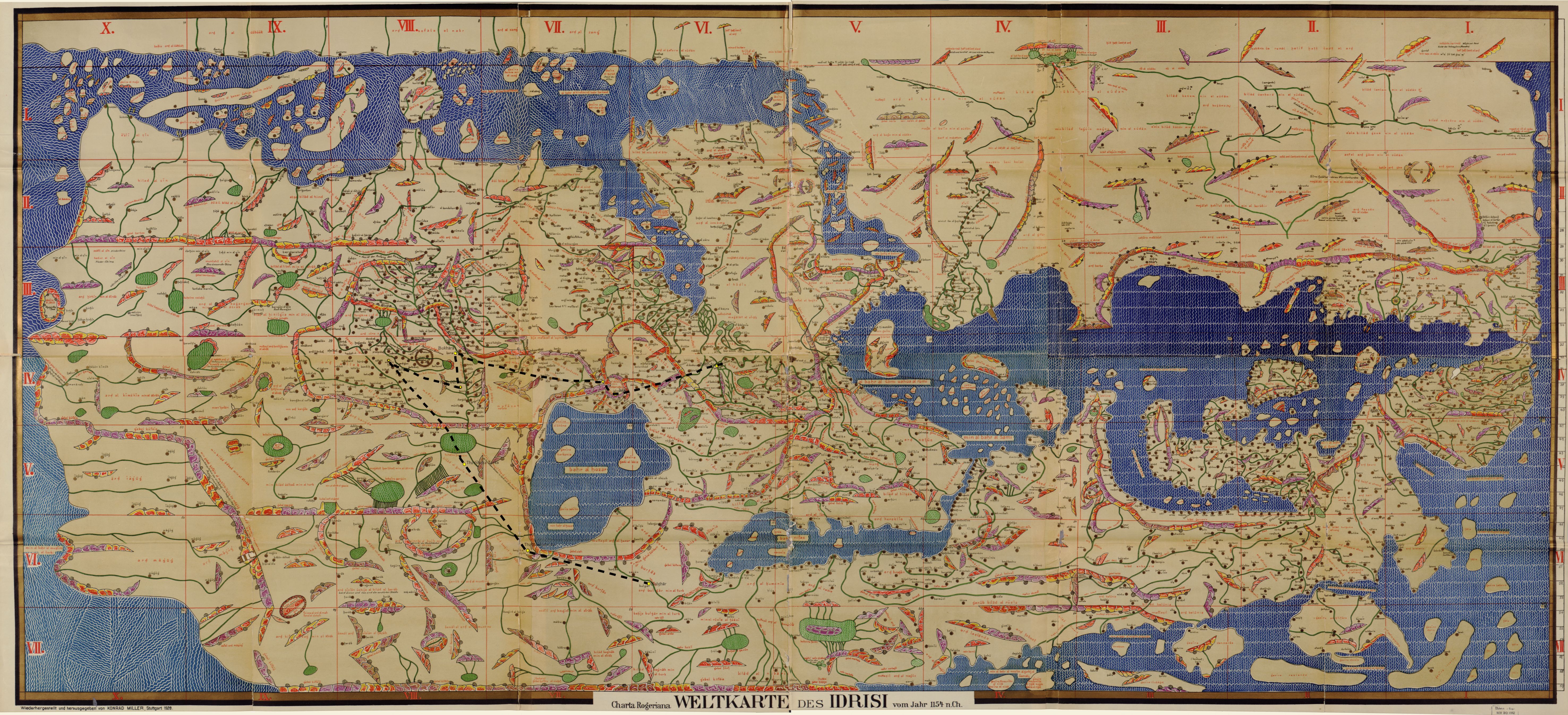
Nahrawan to Sawa (orange); Sawa to Simnan (green); Simnan to Danaghan (blue); Danaghan to Sarakhs (yellow); Sarakhs to Marw (red); Marw to Bukhara (purple); Bukhara to Khwarazn (brown); Khwarazn to Jurjaniya (black); Jurjaniya to Bulghar (grey)
Sir John Mandeville’s journey is significantly different visually when plotted on the Hereford Mappa Mundi rather than a modern map. Most obviously, because the Hereford Mappa Mundi is oriented with east on top of the world, Mandeville seems to be traveling up and to the right rather than down and to the right. The route plotted on the modern map seems impractical and even nonsensical, in large part due to Sir John Mandeville’s misunderstandings of geography. Once plotted on the Hereford Mappa Mundi, which contains even more geographical mistakes itself, the route which is supposed to be one of the best ways to Jerusalem seems even more ridiculous. Both maps have several places where Mandeville seems to double back on himself or make a small loop, but on the modern map the loop takes place in the coastal cities of Syria and Israel, most likely due to Mandeville’s misunderstanding of how the cities are ordered down the coastline. However, on the Hereford Mappa Mundi, not only does John Mandeville not know where some of the locations he claims to have visited are located, but the map’s author does not know either. Most obviously, the labyrinth on the map that represents the island of Crete (where John Mandeville describes visiting Rhodes) is drawn much too far south in the Mediterranean, nowhere near Greece or Turkey. The island of Cyprus is not labeled at all, so I chose a larger island close to where it would realistically be located based on the modern map and called is Cyprus. I did the same with the coastal towns and cities of Syria and Israel, labelling them along the coast as closely as possible to where they were located on the modern map. The Hereford Mappa Mundi also did not have Saint Albans or Nicaea on the map, so I set them in the middle of England and Turkey, hopefully close to where they might be located. Overall, however, the Hereford Mappa Mundi is surprisingly accurate for the time. Sir John Mandeville’s ridiculous route looks very similar on both the medieval and modern map.
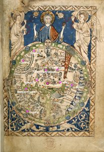
In the beginning, mapping the first place from John Mandeville’s narrative onto the Psalter World Map, was actually relatively easy. One of the reasons that I chose the Psalter map was because it included a small part of England which the author claims as his home country. The inclusion of England in the map is unusual so it was easy to find because most of the historical sources I used pointed specifically to this distinction. My second point, Constantinople, was harder to find because the labeling on the map is difficult for me to read. I was able to find “roma” and from there located “grecia.” Then, comparing the waterways on the medieval map that seemed to be the Mediterranean Sea and the Black sea to where they are on the world map we know today, I tried to accurately guess where Constantinople would be. Luckily, my third point, Jerusalem, was even easier to find than England, because it’s in the center of the map and clearly labeled, but Damascus was harder because there was no label that I could read that resembled it or anything near it. I knew it was near Jerusalem and on the other side of the body of water from Constantinople but I just had to guess from there. I knew that Africa was supposed to be towards the bottom right of the map, so I looked closer to that side for Babylon. I found a label that I think says Babylon in that area, so I placed it there. For Gaza I tried to employ the same strategy I used for Constantinople. I compared where the Red Sea was on the Psalter Map to where it was on today’s map, and using Jerusalem and Babylon as fixed points, tried to guess where Gaza would be.
However, once I got those first six points down, the rest of the places I mapped in my modern map were almost impossible to map in the second. East of Jerusalem on the Psalter Map seems to be made up of nothing but illegible labels and the way to Paradise. The only way that I was able to even try to guess where my last points were on the map was knowing that it was a flipped version of the map that I was used to, with east at the top, and drawn in a “T” shape, with all of Asian taking up the big side of the t. Again, I tried to compare it with the real map of the world, and guess where the four remaining points would go if the Psalter map were similarly constructed. Overall the mapping got incredibly difficult the farther east the points went. This shows how little the medieval people actually knew about what was East of Jerusalem. They had no idea how big the area of Asia or Russia was, or where anything was located. This reflects how John Mandeville’s narrative proceeds East as well, because he seems to not know where anything is actually located when he describes India and Asia.