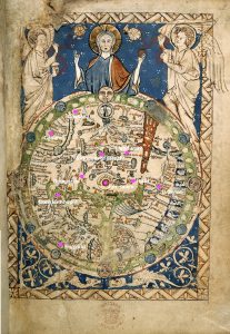
In the beginning, mapping the first place from John Mandeville’s narrative onto the Psalter World Map, was actually relatively easy. One of the reasons that I chose the Psalter map was because it included a small part of England which the author claims as his home country. The inclusion of England in the map is unusual so it was easy to find because most of the historical sources I used pointed specifically to this distinction. My second point, Constantinople, was harder to find because the labeling on the map is difficult for me to read. I was able to find “roma” and from there located “grecia.” Then, comparing the waterways on the medieval map that seemed to be the Mediterranean Sea and the Black sea to where they are on the world map we know today, I tried to accurately guess where Constantinople would be. Luckily, my third point, Jerusalem, was even easier to find than England, because it’s in the center of the map and clearly labeled, but Damascus was harder because there was no label that I could read that resembled it or anything near it. I knew it was near Jerusalem and on the other side of the body of water from Constantinople but I just had to guess from there. I knew that Africa was supposed to be towards the bottom right of the map, so I looked closer to that side for Babylon. I found a label that I think says Babylon in that area, so I placed it there. For Gaza I tried to employ the same strategy I used for Constantinople. I compared where the Red Sea was on the Psalter Map to where it was on today’s map, and using Jerusalem and Babylon as fixed points, tried to guess where Gaza would be.
However, once I got those first six points down, the rest of the places I mapped in my modern map were almost impossible to map in the second. East of Jerusalem on the Psalter Map seems to be made up of nothing but illegible labels and the way to Paradise. The only way that I was able to even try to guess where my last points were on the map was knowing that it was a flipped version of the map that I was used to, with east at the top, and drawn in a “T” shape, with all of Asian taking up the big side of the t. Again, I tried to compare it with the real map of the world, and guess where the four remaining points would go if the Psalter map were similarly constructed. Overall the mapping got incredibly difficult the farther east the points went. This shows how little the medieval people actually knew about what was East of Jerusalem. They had no idea how big the area of Asia or Russia was, or where anything was located. This reflects how John Mandeville’s narrative proceeds East as well, because he seems to not know where anything is actually located when he describes India and Asia.
