Author: winterch (Page 1 of 2)

Benjamin of Tudela Map Comparison

Unsurprisingly, plotting the journey of Benjamin of Tudela on both a modern and medieval map shines a light on many differences in the way that we view the world as opposed to Benjamin of Tudela.

The first glaring fact when it comes to the visualization on the medieval map is the scope. When looking on a modern map, his travels are impressive, even if one removes the places that he likely did not get to. The Tabula Rogeriana, on the other hand, makes his reported journey stretch from one end of the world to the other (not literally, for it was common knowledge for hundreds and hundreds of years that the world was round). From “Tutila” to “al-Sin”, the particular distortions of this map make it seem that Benjamin of Tudela had passed through a majority of the world’s lands. This is in addition to the fact that the points that are plotted in this map are not representative of his entire itinerary, so there are even more lands that he wrote he had passed through.

There are three major distortions that seem to cause the scope of Benjamin of Tudela’s journey to grow. The first is that Europe is enlarged, and Asia and Africa are diminished, making the lands that he wrote about in more detail (because he actually went to these places) appear more significant than the lands that he spent less time in. The second is the absence of the Americas for obvious reasons. The third is the many distortions made to the southern hemisphere. There is land in these areas, but the shape of almost anything south of Arabia is entirely unrecognizable and seemingly much less dense in terms of geographical features and settlements. This creates the impression that that there isn’t much of import to explore in that part of the world, and the viewer values more the lands that Benjamin’s journeys were meant to have taken place.

While the broad scope of his journey appears more impressive, some of the distances between particular locations seem more reasonable on the medieval map than on the modern. The locations marked in red on the modern map indicate places that Benjamin of Tudela likely did not travel to, and the decision of whether or not it was likely he went to a particular location was made mostly based off the fact that the routes that he would have had to take were highly erratic and nonsensical.

There are two main reasons why this is not quite the case on the medieval map. First off, some of the locations that he wrote about were not featured on the Tabula Rogeriana, particularly Rudbar and Amedia. These locations’ absence make it plausible that contemporaries could have believed that Rudbar and Amedia were on the route from Susa to Hamadan, making Benjamin of Tudela believe he could pass off actually going through those locations. This theory would further exemplify that Benjamin of Tudela did not really travel to these places, and that common knowledge was that Rudbar and Amedia were inland towns betwen Susa and Hamadan.

The second reason is that land distortions make routes that are actually irrational appear more reasonable. A significant example of this is the distance between Hamadan and Samarkand. On the Tabula Rogeriana, it visually appears to be about the same distance as that between Hamadan and Aleppo (Haleb). In reality, the direct distance between Hamadan and Aleppo is roughly 650 km, while the distance from Hamadan to Samarkand is over 1000 km. At this point, Benjamin of Tudela had traveled well over 1000 km, but in his itinerary there is shockingly little information about the lands between these two places. In the text, it appears as if the journey between Hamadan and Samarkand is no big deal, while in reality it makes absolutely no sense how he could have gotten that far east given the textual evidence to work off of.
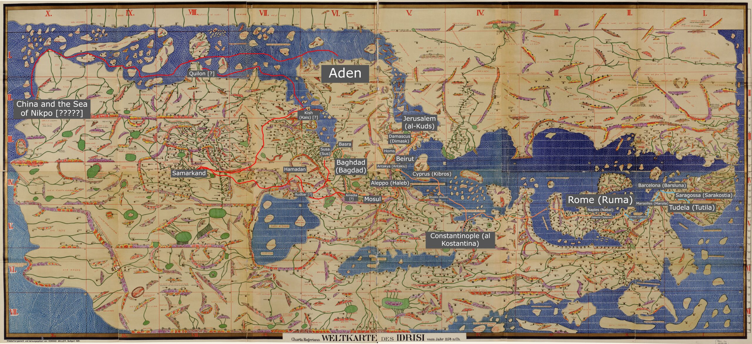
Benjamin of Tudela Medieval Map

Zoom in to see all the locations!

The blue route simply marks his terrestrial travel from his home to the first major location, Rome (Ruma).

The orange route marks the rest of his plausible route.

The red route indicates places that he likely did not travel.

When a location is followed by one or more question marks that just indicates that it either wasn’t on the Tabula Rogeriana or that I just didn’t find it. China and the Sea of Nikpo have several question marks because……. I truly just can’t figure out what he thought was going on in that corner of the world.

The Itinerary of Benjamin of Tudela: ‘Bagdad’ (Baghdad)

Benjamin of Tudela eventually makes his way across the Arabian Desert to the powerful city of Baghdad. In many ways it seems to equate to Rome at the time, for here was seated the Caliph, the successor to Mohammed and the head of the Islamic faith. He immediately draws the obvious comparison relating to the early parts of his travels in saying the Caliph “occupies a similar position to that held by the Pope over the Christians.” (p. 54)

The entry on Baghdad stands out for many reasons, but the most immediate of those is the length. Generally when traveling from one place to another, our author seems to take a headcount of Jews, notes whether they live in oppression or peace, and then leaves. This is not how he treats Baghdad. He discusses the Caliph in great detail as well as the structure of the city. 

I think it’s very likely that Benjamin had consistent direct communication with the Caliph for however long he stayed in the city, for during his discussion of the ruler himself he mentions “In the Caliph’s palace are great riches and towers filled with gold, silken garments and all precious stones” (p. 57), and continues for some time to talk about the riches within the palace, the wider palace grounds “three miles in extent” (p. 54), and those that are housed on palace grounds, even those held against their will. There is a wealth of detail here, and on top of this he speaks extremely well of the Caliph. “he is kind unto Israel[…]He reads and writes the holy language [Hebrew]” (p. 55). This all leads me to believe he was often in the presence of the Caliph, although this isn’t for certain because the Caliph did appear to create an air of mystery around himself, and it’s noted that “The men of Islam see him but once in the year” (p. 55). It is unclear if this scarcity of figure also applied to Benjamin, but the rest of the evidence would seem to indicate otherwise. Jews in Baghdad live extremely well by Benjamin of Tudela’s standards, and there are many of them. He notes 40,000, and again says that their wellbeing is largely due to the Caliph, saying “they dwell in security, prosperity and honour under the great Caliph” (p. 60). 

Benjamin of Tudela does not spend any time in his writings discussing the practicalities of his travels, nor does he mention what he spends his time doing during his stops. However, we learn more about Benjamin himself here than anywhere else in the text. We can somewhat deduce that he spent a lot of time here due to the lavish detail, he clearly was treated with respect and honor himself and was welcomed to the city at the heart of the Islamic world. There isn’t much, but it is something.

Again, our author’s goal is pretty clear: document Jews across the world. There is no way to know whether his estimate of 40,000 Jews in Baghdad is accurate in any sense, but he was clearly impressed with the Jewish population in this area and at their treatment.

Benjamin of Tudela Modern Map

https://www.google.com/maps/d/u/0/edit?mid=1NqdnXUKJjX98iqW82l6Pm-h7XehurCXN&usp=sharing

Yellow: Europe

Green: The Levant and Surrounding Sites

Blue: Along the Tigris and Euphrates

Red: Likely false account


Noted Locations:

Rome, Constantinople (Istanbul), Antioch (Antakya), Beirut, Jerusalem, Damascus, Emesa (Homs), Aleppo, Mosul, Bagdad (Baghdad), Babylon (Hillah), Susa (Shushan, Shush) Rudbar, Amedia, Hamadan, Samarkand, Kish, Quilon, China (Nikpo?), Aden

« Older posts

© 2024 Mapping the Global Middle Ages


Academic Technology services: GIS | Media Center | Language Exchange

Theme by Anders NorenUp ↑