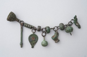
CREPUNDIA: a child’s toy rattle, sometimes used for identification; infancy
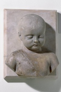
Marble bust of a sleeping child wearing crepundia (amulets and charms) on a cord across his chest. © The Trustees of the British Museum.
Ebony comes from India and Ethiopia, and when cut it becomes hard as stone . . . it is also attached to crepundia, so that the sight of the color black will not scare the infant. (Isidore of Seville, Etymologies 17.7.36)
All too transitory and fragile, like the crepundia of childhood, are the so-called power and wealth of human kind. (Valerius Maximus, Memorable Deeds and Sayings 6.9 ext. 7)
From infancy [a crepundiis] he gave equal attention to courage and to eloquence. (From an inscription honoring Flavius Merobaudes, an imperial official and writer of poetry of the fifth century, CIL 6.1724.)
Now in here are the crepundia you had when that woman brought you to me years ago. She gave them to me so as to make it easier for your parents to recognize you. (The madam at a brothel, to one of her courtesans, in Plautus’s comedy Cistellaria 635–636.)
She had already given an indication that she was destined for heaven and not for the couch of marriage: she had rejected her very crepundia, a little girl who knew not how to play. No interest in amber, she wept at roses, disdained aureate bracelets, was sober of expression, modest of gate and, though of all-too-tender years, her character imitated that of gray-haired age. (Prudentius, on the twelve-year-old martyr Eulalia, killed in Merida, Spain in AD 304, Crowns of the Martyrs 3.16–25.)
Crepundia derives from the verb meaning “to rattle” (crepare) and refers in the first instance to the metal charms jingled to try and calm fussing babies. From there crepundia comes to stand in as a symbol for early childhood itself, as in the comment of Valerius Maximus and the inscription quoted above. Unlike today, when such things are generally mass-produced, a Roman tot’s crepundia were homemade and individualized. They might be inscribed with the name of the mother or father, or include some distinctive figurines. Archaeologists have found bells, clappers, letters of ivory, children’s utensils for eating and drinking, and many other objects that served this purpose.
Since they were individualized, crepundia could be used to identify babies who got misplaced. Special crepundia could be given to children by mothers who were compelled by poverty to expose them or give them away, in hope that, when they had grown up in someone else’s care, they might by some chance return and be recognized using the crepundia. Such improbable recognitions of lost or abandoned children, duly verified by crepundia, were a common plot device in Roman and Greek comedy, as in the line from Plautus quoted here.
But this does not mean it never happened in real life. The real rate of child abandonment in ancient Rome is unclear. By one estimate, impossible to verify, 20 to 40 percent of all urban children were abandoned in the third century AD. This is a very high figure, and probably not a normal situation, but it is well paralleled in pre-industrial Paris, Vienna, Milan, and Florence in the eighteenth and nineteenth centuries. The comparative evidence corroborates the impression we get from Roman sources, that the prototypical abandoner was an urban woman, perhaps from a peasant background in the city as a domestic servant, for whom taking care of an infant interfered with the necessity of urban employment. The modern evidence suggests that, unlike the happy endings of Roman comedy, however, abandonment was often tantamount to infanticide. Eighty percent mortality and higher in the first year was regular, even when foundling homes were in place (which they were not in ancient Rome).
Just as crepundia were fragile and fleeting, childhood itself was seen as a time of immaturity and imperfection. Roman children were often praised by adults for not acting like children—that is, for being serious, responsible, and sober, like adults—the so-called senex puer or “old-man boy” phenomenon. Prudentius follows in this tradition when he praises the young martyr Eulalia for wanting to have nothing to do with her crepundia, and “not knowing how to play.”
Bibliography: Thesaurus Linguae Latinae 4.1174–1175. J. Marquardt, Das Privatleben der Römer (repr. Darmstadt: Wissenschaftliche Buchgesellschaft, 1980) 1.120. Susan Dixon, The Roman Family (Baltimore: Johns Hopkins University Press, 1992) 98–132; David Kertzer et al., “Child Abandonment in European History: A Symposium,” Journal of Family History 17 (1992) 1–23.
 Adapted from the book Ancient Rome in So Many Words (New York: Hippocrene, 2007) by Christopher Francese.
